
Caitlin Dempsey

These Cities are the Most Unaffordable Places to Buy a House in the World
Urban Reform Institute and Frontier Centre for Public Policy evaluated housing markets for 92 metropolitan areas in eight countries to see how affordable they area.

Half of the United States Will Continue to be Affected by Drought for Spring 2021
Drought conditions in much of the United States are forecasted to continue for spring 2021.

View From Space: Stuck in the Suez Canal
Satellites have captured imagery of the Ever Given which is currently stuck in the Suez Canal.

What Was the First Map Issued by the Ordnance Survey?
The first Ordnance Survey map was issued in 1801.

The Earth’s Only Active Volcano Known to Emit Natrocarbonatites
Only one active volcano in the world is known to emit natrocarbonatite.

2020 Hurricane Season
Each year, the World Meteorological Organization creates a list of official names for major storms in the both Northern Pacific and Atlantic oceans.

GIS Data for California Public Schools
California School Campus Database (CSCD) offers a GIS dataset that contains all of the public school locations from K-12 grades for California.

Climate Change is Increasing Post-Wildfire Landslides in Southern California
A recently published study has forecasted that climate change is driving increased wildfire and landslide risk in Southern California.

The United States Ranks Third for Historically Active Volcanoes
The United States ranks behind Indonesia and Japan for historically active volcanoes based on written records.

Mount Etna Erupts
Mount Etna's latest eruptions occurred on February 16 and again on February 18, 2021.

Highlight Your Skills with a GIS Portfolio
A GIS portfolio is a way to digitally present GIS projects and maps that you have created.

The Polar Vortex is Causing Extreme Cold in Parts of the United States
A disruption of the polar vortex has allowed extremely cold air to descend to over parts of North America as far south as Texas.

Quick Geography Facts About Planet Earth
Find quick information about planet earth including the age, mass, volume, and make up of the earth's crust.
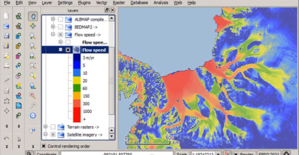
Quantarctica – Free GIS Data for QGIS
Quantarctica is a collection of freely downloadable GIS data for Antartica.

What is a Cartifact?
A cartifact is an object containing a map that is used primarily for design rather than as a source of information.

Mount Fuji’s Snow is at a 20-Year Low
Satellite data that has tracked snow cover on Mount Fuji shows that the 2020 snow levels are the lowest since 2000.

Climate Change is Shrinking Forests in North America
The impact of climate change is reducing the amount of habitat where the trees of North America can thrive.

West Virginia’s First National Park
West Virginia's New River Gorge National Park and Preserve became the latest national park when it was designated as such by the U.S. Congress in December of 2020.

World’s Largest Active Geyser
Located in the Norris Geyser Basin in Yellowstone National Park is Steamboat Geyser, the world's largest active geyser.

Using Stingrays to Map the Ocean Floor
One research lab in Japan is looking at using marine life to collect 3D geospatial data about the ocean floor.

Hub for Free Remote Sensing Materials
Esri has launched a hub that will serve as the collection point for free remote sensing and imagery materials

Geography Facts About Death Valley
Learn some interesting geography facts in this article about Death Valley.

The Lowest Point in Every U.S. State
This article takes a look at the lowest elevation point in every state in the U.S.

Rivers in the United States are Changing Colors
A team of researchers analyzed Landsat images over a 38-year period and found that a significant number of large U.S. rivers are changing colors.