
Caitlin Dempsey

These Clouds Only Predictably Form in Australia
Morning Glory clouds are a unique and rare cloud formation only predictably seen in the Gulf of Carpentaria in Australia during spring.

Kleptotrichy: Birds Who Steal Fur
Scientists recently released their findings on why birds pull fur from animals, which is a potentially risky behavior.

2021 Wildfires in the U.S. and Canada
Climate change is causing wildfires to burn longer and more frequently in some northern latitudes.

Geography of American Bison
Learn about the American Bison, which once roamed North America in large herds.

USGS Releases Two Decades of Land Cover Change for the Contiguous United States
The USGS has updated land cover maps for the conterminous United States, which show how the country's landscapes have changed over the last 18 years.

California’s Drought is Driving Reservoirs to Near Historic Lows in 2021
The second year of California's drought is driving down water levels in the state's reservoirs in 2021.

2020 Global Land Use Data
A GIS dataset of land cover for the entire world was recently released.

The Sonoran Desert is Losing Plants Due to Climate Change
Between 1984 and 2017, a team of researchers utilized Landsat imagery to examine changes in vegetation in the Colorado Desert in Southern California.

Robinson Map Projection
The Robinson map projection is a compromise project that minimizes distortion across the map.

California’s Largest Lake
Floodwater from a broken irrigation canal gate in 1905 created California's largest lake.

Alaska’s Coastline is Longer Than All the Other 49 States Combined
Here are some geography facts about Alaska's coastlines.

Geography Facts About the Rocky Mountains
The Rocky Mountains form the longest mountain range in North America. Here are some geography facts about this mountain range.


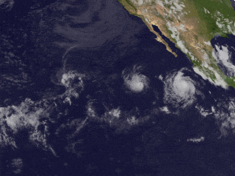
Storms of the 2021 Hurricane Season
While the official 2021 hurricane season officially lasts from June 1 to November 30, 2021, the first storm of the season has already happened.

Preparing for a GIS Job Interview
Navigating the interview process for a GIS position can be challenging due to the field's wide skillset requirements - here are some tips.

Coldest Temperature of Clouds Recorded by a Satellite
Researchers measured the coldest temperature ever recorded by a satellite of a cloud.

Terrestrial Ecoregions GIS Data
The terrestrial ecoregions dataset is available both in shapefile format and as a Google Engine dataset.


80% of Plastic in the Ocean Comes From 1,656 Rivers
A team of researchers analyzed where geographically rivers are the biggest sources of plastic pollution entering the ocean.

Introduction to Geography: Exploring The World Around Us
Geography is the science that studies the Earth and the physical and human influences that shape it.

How the 2020 U.S. Census Shifted Congressional Seats
With the 2020 Census, seven states lost seats and six states gained seats in the House of Representatives.

Views of Earth from Space
Over the decades, Earth has been captured from near and far by astronauts and spacecraft from space.

Largest Alpine Lake in North America
Located in the Sierra Nevada mountain range, Lake Tahoe is a freshwater lake that straddles the border between California and Nevada.

Geography of Hailstorms in the United States
While hail can form anywhere in the United States experiencing a thunderstorm, geography influences where hailstorms are more likely to occur.
Fujiwhara Effect: When One Storm Absorbs Another
When two storms move towards another, an uncommon phenomenon called the Fujiwhara Effect can happen.

Plateaus in Geography
A plateau is a flat section of land that is sharply raised in contrast to the surrounding landscape on at least one side.