
Elizabeth Borneman

How This Remote Island Inhabited by Polar Bears Became Known as Landsat Island
A few unusual pixels in Landsat imagery led to the discovery of a previously unmapped island off the coast of Labrador, Canada.

Sign Language on Maps
The Atlantic Provinces Sign Language Place Names map is an interactive map with place names described in American Sign Language, commonly used across the United States and Canada, as well as a regional dialect known as Maritime Sign Language.

Tracking Deforestation by Measuring the Distance to the Nearest Forest
Using satellite images, researchers established a method of calculating the distance between any point in the continental United States and the nearest forested area.

3.1-Trillion Pixel Landsat 8 Mosaic of the World
Descartes Labs has compiled some of the massive amount of data sent back from the satellites orbiting Earth into a 3.1-trillion pixel composite image of Earth’s surface.

Zealandia: the World’s 8th Continent
As it turns out, we might have one more continent to add to Earth’s collection. The continent, dubbed Zealandia, is composed of nearly 5 million square kilometers of land including New Zealand and New Caledonia and is mostly underwater.

Mercury Levels Greatest Among Marine Birds in Western North America
A research study has identify areas in North America that are hotspots affecting mercury blood levels in birds.
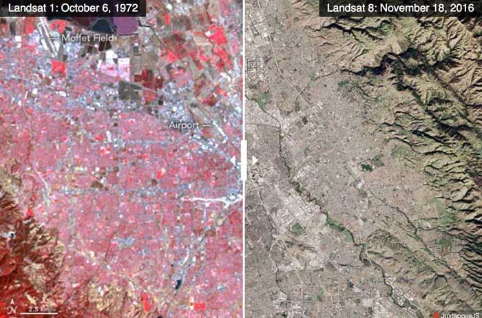
Advances in Landsat Sensors
Since those first images in 1972, multiple Landsat satellites have been launched with the ability to take increasingly detailed pictures of our world.

Restoring a Salt Marsh
The San Francisco Bay was once connected to a large salt marsh that contained many different and rare species of plants and animals. Conservationists are now restoring the salt marsh.

These US Towns Each Have Less Than 15 Residents
Here are a few smaller than small towns in the United States.

Mapping Urban Trees Using Google Street View imagery
A project by the MIT Senseable City Lab, dubbed Treepedia, has mapped the amount of trees that were growing in major urban areas.

Using Green Space to Reduce Water Pollution
Researchers have used satellite data to analyze images for areas that should be protected as green spaces which in turn help protect Atlanta’s water supply.

Study Examines Trends in Global Warming
A multi-institutional study has recently come out with new research that studied the temporary slowdown of rising temperatures around the Earth.

Mapping Billions of Data Points in Milliseconds
With its GPU power, MapD can process and map billions of data points in milliseconds.

Using Machine Learning and Satellite Imagery to Estimate Corn Crop Production
Descartes Lab, a start-up organization, has created crop production analysis that uses millions of satellite images and machine learning to produce accurate data about the production of agricultural crops.

GPS and a Grader Bring Back the Maree Man Geoglyph in Australia
The Marree Man is a geolyph located in the Australian Outback. A geolyph is an image or a picture that is a design in the earth, and it is usually made of natural materials.

How the Commutes of 130 Million Commuters Reveals Megaregions in the United States
A study using data from 130 million commuters has revealed commuter-driven megaregions in the United States.
![Meandering river in Nyingchi, Tibet, China [view in Timelapse] (Image credit: Landsat / Copernicus*). Via: Google](https://www.geographyrealm.com/wp-content/uploads/2020/08/Timelapse-Tibet_China.gif)
Update Google Earth Time Lapse
Google Earth has released a new time-lapse of the Earth, composed of over 5,000,000 satellite images.

NASA Exploring Using Mini-drones
NASA has gotten in on the drone action themselves, testing unique mini-drones that are manufactured in Sweden.

3D Print Your Own Universe
Researchers have created a way for people to 3D print their own tiny universes using physics and modern technology.

Spot the International Space Station Using this Map
Even if you can’t reliably see the night sky, you can track the movement of the International Space Station with NASA’s Spot the Station interactive map.

Is this the Most Accurate Worldwide Map Projection?
This new map, called the AuthaGraph, may be the most accurate map projection created to date.

The Map Projection of the United Nations’ Flag
The United Nations flag with a white map on top of a light blue background, is universally recognized. Learn about the map projection used for the logo.

Cartography Without Knowledge: Mapping the Northwest Passage
The University of Southern Maine and the Arctic Council created a map exhibit highlighting the earliest attempts to discover the Northwest Passage.

Interpreting Our World: Viewing the Importance of Geography Through the Lens of 100 Historical Events
The book Interpreting Our World is a new geography text analyzing 100 events in history that dramatically altered how people ...

NASA: September 2016 Warmest on Record:
Nasa’s Goddard Institute for Space Studies (GISS) has announced that September 2016 was the warmest September ever recorded around the globe.