
Mark Altaweel

Geography of Beliefs
Geographic factors can shape our beliefs not only in our early life and development years, but they can also affect us as we move and change where we reside throughout our lives
Geotargeting by Advertisers and Government Agencies
Geotargeting by advertisers, which is the practice of sending advertisement based on location, has gained increased importance for companies marketing their product in recent years.

Mapping the Universe
New satellite technology achieved in in the last decade are helping scientists to more accurately map the universe.

Using GIS to Map and Track Vandalism
GIS is being used to better understand current and potentially future patterns of vandalism.

Using GIS to Assess the Impact of Electric Cars
GIS and spatial analysis may help find some practical solutions for electric vehicle charging.

Cloud-based Geospatial Analysis
We will see more migration of spatial and GIS work to cloud-based platforms in the near future.

GIS and Migrant Deaths in the United States
Spatial analysis and GIS is being used in the study of migrant deaths to not only better track routes taken but also use results from research to limit deaths and danger to migrants.

Mapping Epidemics
Forecasting the spread of viruses and mapping potential epidemics is gaining important attention in the medical community.

Mapping Australia’s Bushfires
Tools based on near-real time data from satellites, such as those used by Australia or developed by NASA, have great utility in monitoring existing fires while giving the public near real-time monitoring.
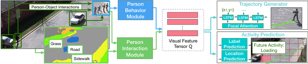
Predicting Future Movements of Pedestrians and Autonomous Vehicles
As driverless cars and motion detection technologies are increasingly integrated into our everyday lives, applications are now being developed to help with predicting movements undertaken by both pedestrians and vehicles.

Biodiversity and Climate Change Adaptation
Many cities globally are forging ahead with climate change adaptation.

Automated Remote Sensing of Underground Features
Below ground mapping can now better utilize remotely sensed data to create more accurate maps.

EarthPy: Python Package for Plotting and Working with Spatial Data
A Python language spatial package, called EarthPy, has been released for free download for working with GIS data.

Creating a Spatial View of the Brain
Mapping small scale but complex organs such as the human brain is requiring new technologies and spatial modeling to be developed.
DNA Science and GIS
In recent years, spatial analysis has supplemented our understanding of genetic variation and DNA studies.

Using GPS to Improve the Accuracy of Drone Mapping
By improving the precision of the GPS devices on UAVs, it is now possible to create much more accurate maps without needing to physically visit the area in order to ground truth.

Mapping the World’s Islands
A new USGS and Esri project has mapped 340,691 of Earth's islands, creating a publicly available GIS dataset.
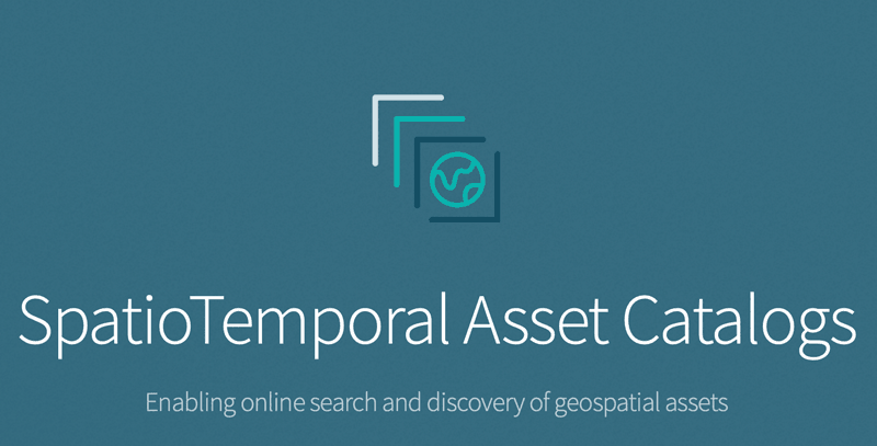
Making Finding Geographic Information Easier: SpatioTemporal Assets Catalogs
SpatioTemporal Assets Catalogs (STAC) provides a common set of search terms so that geospatial information can be found and indexed easily.

Geospatial Data and Sustainable Development Goals
The new initiative, called Data for Now, will see the linkage of Google Earth satellite data and other GIS data with UN data.

Community Involvement in OpenStreetMap
While we often assume that the OpenStreetMap (OSM) community is primarily made up of individuals, large corporations are increasingly active in the development of OSM.

World Bank and Geospatial Data
The World Bank in August 2018 launched the Integrated Geospatial Information Framework, which is seen as a way for GIS data to be provided for governments, NGOs, and companies to make more informed decisions that not only benefit their economies but also enable sustainable development.

Finding Pleasant Routes Using GIS
GIS is being to used to plan pedestrian routes not based on the fastest way but centered on finding the quietest, shadiest, or most pleasant paths.

Using Geospatial Analysis to Map the Optimal Places for Tropical Rainforest Restoration
Using peer-reviewed GIS datasets and remote sensing data, 88% of the needed restoration effort could focus on just six countries that are likely to help restore tropical rainforest growth.

What the Rise of Small Satellites Means for Geospatial Data
Small scale satellites are changing how we can acquire our data as geospatial analysts.

Platforms for Making Deep Learning Easier for GIS
New tools have been developed to facilitate the integration of deep learning tools within GIS applications.

Voronoi Diagrams and GIS
Voronoi diagrams can be created by many GIS packages today for understanding spatial patterns.