
Mark Altaweel

Mapping the Human Footprint
The world settlement footprint, created in a online application called Urban Thematic Exploration Platform (TEP) sponsored by the European Space Agency (ESA), is the first map that combines optical and radar satellites to create a human urban footprint map of the world.

Using Crowdsourcing and Deep Learning to Map Human Settlements
Machine learning techniques are being used to map new urban and land use patterns that were previously difficult to detect using crowdsourcing data.

How Google Earth Engine Has Changed Access to Remote Sensing Data
Google Earth Engine provides access to remote sensing data without requiring advanced software or skilled geospatial technicians.
Uber’s Open Source Mapping Tool
In 2016, kepler.gl, Uber’s mapping tool used to track and map journeys on its popular ride hailing application, was released as an open source project by the company.
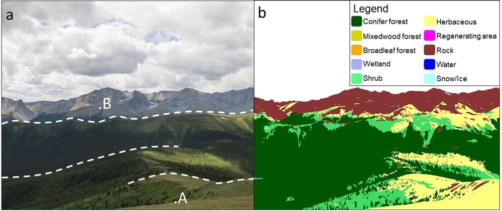
Using Historical Photographs to Map Landscape Change
Researchers used historical photographs, some dating back to the mid-19th century, to analyze changes in landscapes.

How Refugees are Using GIS to Map Their Geographies and Experiences
Story maps are a powerful tool that visualize events and what has happened to those who are displaced.

Analyzing the Benefits of Green Space on Mental Health Using GIS
A study in Denmark combined historical Landsat satellite data and a survey to analyze the relationship between green space and mental health.

Mapping Where Planting Trees Can Help with Climate Change Mitigation
Researchers have mapped out where to plant trees to mitigate climate change.

Geography of Vulnerability: Which Communities Are Most Affected by Wildfire?
Communities that live close to areas where forest and brush fires occur, at least in the United States, have been recently demonstrated to be predominately African American, Hispanic, or Native American.

Changes to the National Land Cover Database
The National Land Cover Database is a GIS dataset that is seen as critical for monitoring the impact of fires, particularly increased wildfires in the West, general health of ecosystems, biodiversity monitoring, and increasing effects of climate change on land cover.

Gini Coefficient and GIS: Mapping Income Disparities
The Gini coefficient is a long-standing measure used by major organizations, such as the UN and government entities, to measure disparities between income and wealth in countries.

GIS and the US 2020 Census
The 2020 Census promises to be the most technically advanced census undertaken, where data, for the first time, will be mostly collected online.

How Redlining Communities Affects Health
New methods have also been created to measure inequality to housing and health so that they can be empirically demonstrated

Mapping Migration Based on Search Data
Researchers have create ways to map migration based on online searches of migrants as they prepare to leave their country of origin.

Real-time Fire Mapping and Satellite Data
New satellites and improved image processing methods are better enabling the ability to provide real-time and near real-time mapping of wildfires.

First Data from NASA’s GEDI Program to 3D Map Forests
The first set of data that have returned have demonstrated GEDI is able to measure density of forests far better than previous satellite missions.
GIS and Blockchain
For Earth observation and GIS technologies, researchers have only recently begun contemplating what might be useful in applying blockchain technologies.

Mapping Land Cover by Stacking Landsat Imagery
Landsat 8 is offered as free, open data, which has led to new innovation in methods to better utilize such data for time series and complex scenes that are sometimes obstructed by clouds or dust.

Using GIS to Analyze People’s Attitudes
GIS can help researchers analyze spatial data within social media posts in order to understand how people react to different features in their environment.

Mapping School Performance and Inequality With GIS
With GIS, researchers can look at how effective schools are relative to spatial measures.

Spatial Income Inequality and Climate Change
The relationship between CO2and climate change emissions in general and wealth inequality is not a clear one.

The Geography of Borrowing Size
Towns can 'borrow size' from nearby urban areas, enhancing their economic prospects and resilience by leveraging networks with larger towns.
What Helps to Increase Public Participation in GIS?
Community participation in GIS through PPGIS is a worthy goal and has been applied in many studies for decades.

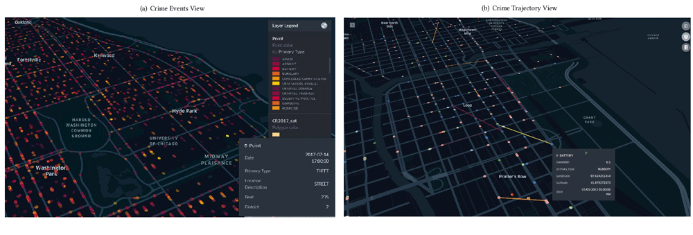
Using GIS to Assess Crime Risk
The use of GIS and spatial analysis has become an important tool in understanding crime patterns.

Using Machine Learning and Surface Deformation Data to Predict Earthquakes
There is no easy solution for earthquake prediction, but machine learning in particular has made forecasting far better.

GIS and Named Entity Recognition: Identifying Geographic Locations in Text
New methods in natural language processing are being developed that are merging geographic information with basic texts and human language.