
remote sensing

Developing Damage Proxy Maps from Satellite Data
Satellite data is being used to create Damage Proxy Maps to assess changes in an area as the result of natural disasters like Hurricane Maria in Puerto Rico, and the wildfires that have hit Northern and Southern California.

Seafloor Mapping Techniques
Today, seafloor mapping is essentially a form of remote sensing that uses similar concepts and applications to satellite-based systems, albeit adapted to the complex environment of the oceans.

Will 2017 be Remembered as a Stellar Time for Earth Observation?
Joe Francica, Managing Director Location Intelligence Solutions with Pitney Bowes discusses the growth and direction of Earth Observation satellites.

Monitoring Air Pollution with Sentinel-5P
Sentinel-5p will be one of the first satellites that provides high resolution pollution monitoring and will provide a large data capture that enables daily and even hourly monitoring.
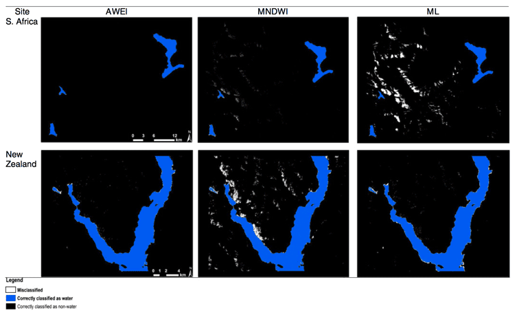
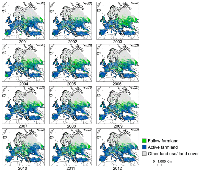
Automated Land Cover Maps
Automating the generation of land cover maps from satellite imagery is becoming easier due to learning-based algorithms improving the understanding of signal data.

Methods for Creating Cloud Free Satellite Imagery: Sentinel 2
Nearly 70% of the globe is covered by clouds at any given time. Several methods have been developed to remove cloud cover from satellite imagery.
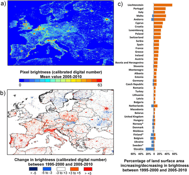
How Geospatial Technologies Are Being Used to Study Light Pollution
Spatial technologies, including remote sensing and GIS, have been used to monitor light pollution and its associated degradation effects.

Jason-2 Satellite to Help Improve Maps of Sea Floor
Jason-2 will be collecting data about the sea floor every 5 miles, which will be used to create a high-definition estimate of the average surface height of the ocean in various places around the globe.
Measuring Vegetation from Satellite Imagery with NDVI
Normalized difference vegetation index (NDVI) is a remote sensing technology that measures vegetation kinds and growth by measuring vegetation fingerprints.

A New Algorithm to Find Wildfires When It’s Cloudy
New technology called the Firelight Detection Algorithm, or FILDA, can help detect wildfires at night even when the skies are cloudy.

A Global Landslide Potential Map That Updates Every 30 Minutes
Researchers from NASA have developed a global landslide susceptibility model that maps out areas in danger of potential landslides every thirty minutes.

Understanding Ocean Wave Patterns from Satellite Imagery of Sun Glitter
Researchers have developed a method by which to translate satellite imagery of sun glitter on the water into data about the direction, height and movement of waves.

ESA’s Swarm Satellites Reveal Detailed Variations in the Earth’s Magnetic Field
Three years of data collection the European Space Agency's (ESA) Swarm satellites has resulted in the highest resolution map of Earth’s lithospheric magnetic field.

Using Visual Search to Find Geographically Similar Features on Satellite Imagery
Descartes Labs recently unveiled its GeoVisual Search application which uses machine learning to visually search satellite imagery for similar geographic features.

Tracking Deforestation by Measuring the Distance to the Nearest Forest
Using satellite images, researchers established a method of calculating the distance between any point in the continental United States and the nearest forested area.

Learn How to Access and Use Sentinel-3 Data
Learn how to download and use earth observation data from ESA's Sentinel-3 satellite.

Using Machine Learning and Satellite Imagery to Estimate Corn Crop Production
Descartes Lab, a start-up organization, has created crop production analysis that uses millions of satellite images and machine learning to produce accurate data about the production of agricultural crops.

VANE Query Language: Intuitive Access to Satellite Imagery
Georgy Potapov of OpenWeatherMap introduces the release of the VANE language service, an entirely online service that presents a new concept for accessing satellite imagery. Potapov shares OpenWeatherMap’s vision of how developers can work with satellite and weather data to help the overall geoinformation market to grow.

Using GIS in Landscape Archaeology
Landscape archaeology is a discipline where space is critical to understanding ancient settlements and human use of ancient space. The use of GIS is steadily growing as a tool in this field.

Using Remote Sensing to Understand the Correlation Between Deforestation and Forest Fires
MAAP has used remote sensing to discover a correlation between deforestation and forest fires in Tampbopata, Peru.

Mini Satellite Constellation to Explore the Outer Reaches of Our Atmosphere
An international scientific project is conducting an unprecedented study of the atmosphere’s outermost layer. Fifty tiny satellites will measure the attributes of the thermosphere, a poorly understood but vitally important region.
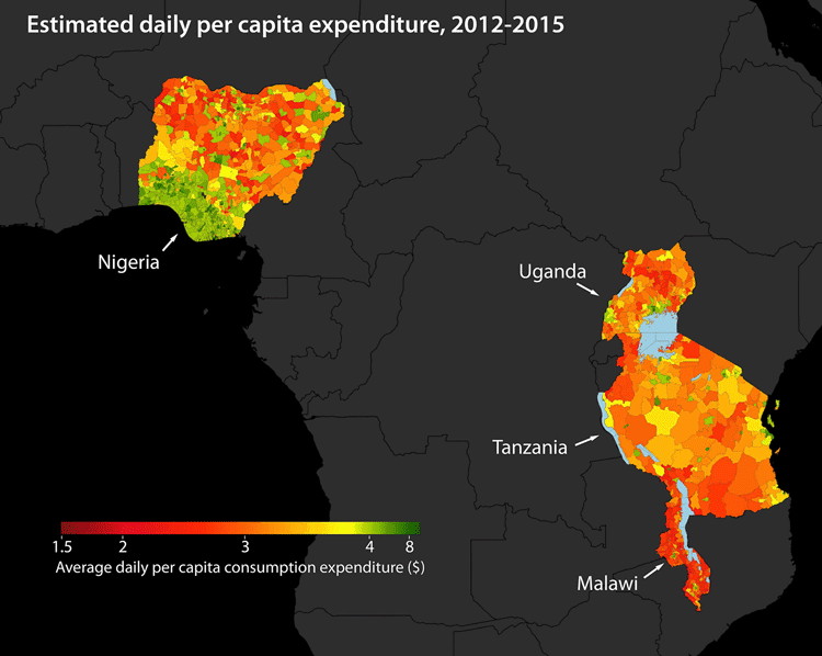
Using Machine Learning to Map Poverty from Satellite Imagery
Satellite images are now being used to map poverty levels around the world using machine learning used to analyze specific poverty data using a convolutional neural network.

Using Satellite Data to Calculate Groundwater
A computer algorithm has been developed at Stanford University that allows researchers to determine groundwater levels using satellite imagery.

Using Remote Sensing to Automate the Detection of Landslides
The Sudden Landslide Identification Product (SLIP) developed by NASA detects landslide potential by analyzing satellite imagery for changes in soil moisture, muddiness, and other surface features.

Building Missing Weather Data
Called the ENACTS (Enhancing National Climate Services) initiative, scientists are using satellite data in order to estimate rainfall, temperature, and other information to fill in a 15 year gap in climate data collection for Rwanda.

Mapping Soil Moisture in Ethiopia Using Remote Sensing Techniques
Remote sensing can be used to assess soil moisture across a region. Learn more about two methods NASA has used to map out soil moisture in Ethiopia.