
Mark Altaweel

Open-Source Science in the Cloud Collaboration
NASA and the European Space Agency (ESA) released a new open source and science tool called the Multi-Mission Algorithm and Analysis Platform (MAAP).

Mapping Ocean Currents
Mapping ocean currents and understanding how they vary is critical for geographers and scientists, especially as our globe changes.
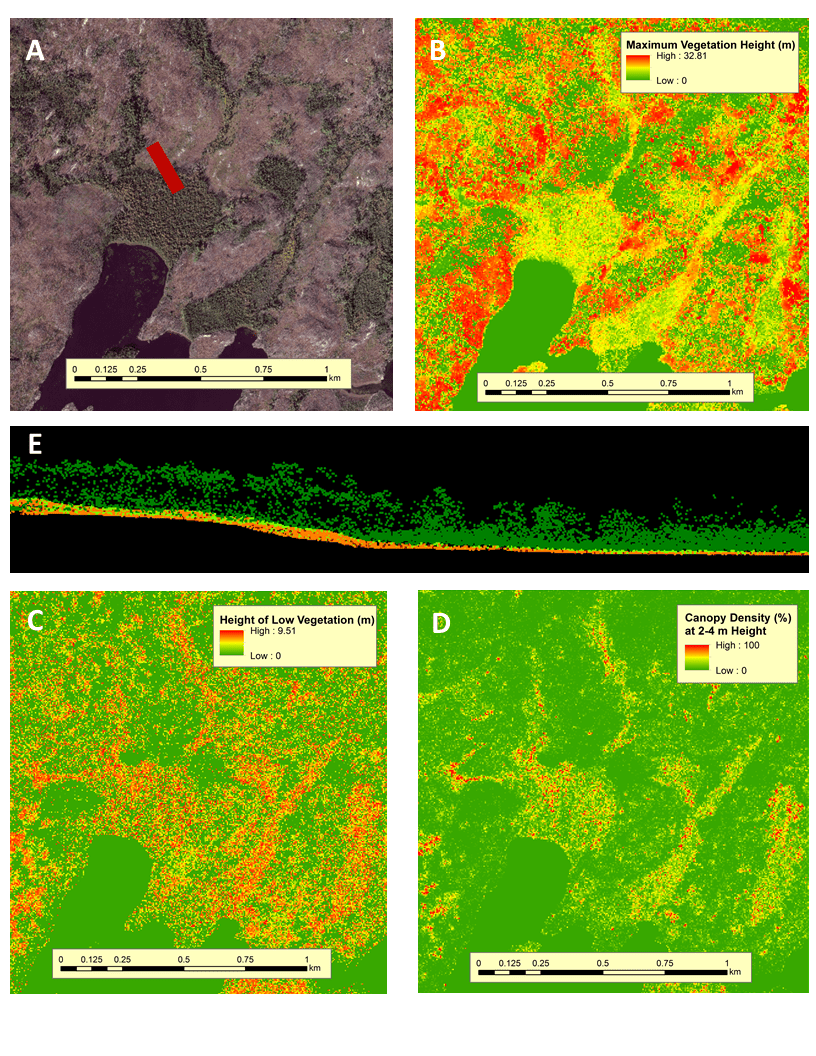
Mapping Ecosystem Health through Satellite Data
Remote sensing techniques, particularly those based on satellite, drone, and aircraft data, have revolutionized collecting ecosystem data.

Mapping the World’s Fungi
Scientists have created a collaborative effort, called the Society for the Protection of Underground Networks (SPUN), which aims to map and protect large areas of fungi.

Mapping Natural Carbon Storage
Scientists have created a map of the Earth where carbon needs to be stored to keep climate goals from Cop26 possible.

World Flood Mapping Tool
The World Flood Mapping Tool, developed by the UN University's Institute of Water, Environment, and Health, aims to help countries with limited data construct flood maps.

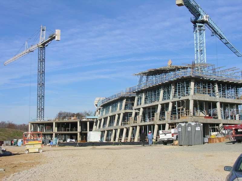
Remote Monitoring of Construction Using Geospatial Technologies
ConsTrack uses satellite imagery, remote sensing, and machine learning to monitor construction activities.

Mapping Feral and Stray Cats
Conservationists are using GIS and GPS to map out feral cat movements to understand impacts on native species.

GIS, Spatial Data, and Agroforestry
Geopatial analysis and GIS are crucial tools for assessing the quality and types of landscapes suited for growing various types of vegetation.
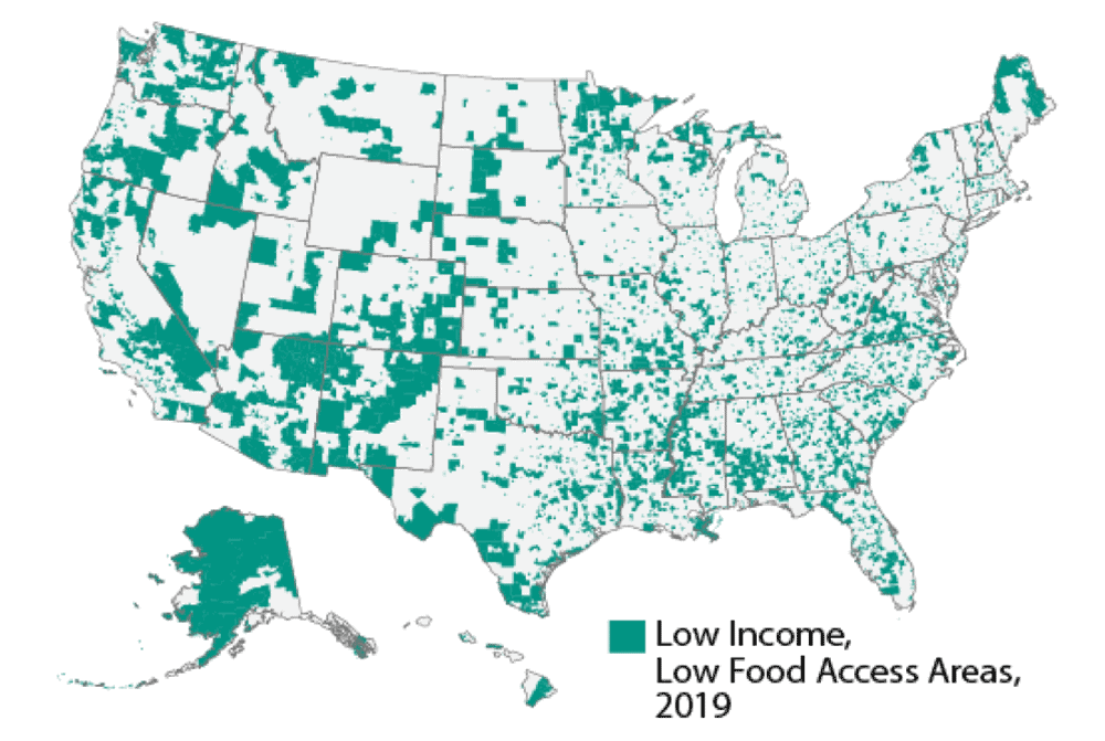
Using Local Knowledge to Better Map Food Deserts
Mapping and understanding food deserts is important if we are to understand how best to tackle the lack of healthy food options in the United States.

Spatial Analysis of Inflation and the Impact of the Pandemic
As countries continue to recover from the Covid epidemic, the latest economic worry is that growing prices and shortages would significantly impact the larger economy.
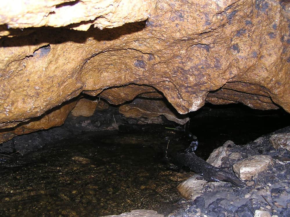
Mapping Underground Features
In recent decades, mapping underground features, such as physical structures or even sounds, has substantially improved.

GIS and Rewilding Efforts
GIS and geographical techniques help identify the best locations for successful rewilding and improve decisions on what to rewild.

Geography and Depression Research
Researchers have looked into how spatial understanding might better enlighten us about mental health and despair.

Mapping Trees in West Africa
Researchers used high resolution satellite imagery and machine learning to map trees in West Africa.
GIS and Building Safety
Both during the construction phase, and after, building safety can be better modeled and understood using GIS.

Survey Markers and Benchmarks
Benchmarks are a type of survey markers whose elevations have been surveyed as accurately as possible based on the technology at the time.

Efforts to Combat Map Vandalism in OpenStreetMap Data
Map vandalism is the deliberate wrong change or update to map data, such as adding an incorrect name for a street or place.
GDAL: Geospatial Data Abstraction Library
The Geospatial Data Abstraction Library (GDAL) is a set of software tools used by GIS platforms such as ArcGIS, QGIS, and GRASS GIS.

Datacubes in GIS
Increasingly, Earth observation (EO) data are stored as datacubes, helping to assist the analytical process.


Super-resolution Imaging
Super-resolution is a technique derived from computer vision approaches that tries to increase the quality of an image by employing algorithms and upsampling to improve image sampling.

Ethics in GIS
With more ways to gather geospatial data and share that information, ethics has become even more important to consider.

Cybersecurity and GIS
GIS can play an important role in ensuring protection of vital infrastructure and data networks.

Deepfake Satellite Imagery
Deepfake satellite imagery is imagery that has been synthetically to alter or change the appearance of an image, often replacing one scene for another.

Carbon Mapper: A Collaboration to Map Greenhouse Gas Emissions
A new, non-profit organization, Carbon Mapper, is attempting to create better ways to pinpoint methane and CO2 emissions.