
GIS and Geospatial Technologies
Articles focusing on the application of geographic information systems (GIS), geospatial technologies, remote sensing, LiDAR, and Global Positioning System (GPS). These technologies serve as critical tools for understanding and interacting with our physical environment. GIS allows for the mapping and analysis of spatial data Geospatial technologies refer to the various tools used to measure and analyze Earth’s lands and resources. Remote sensing provides a way to collect data from a distance, often via satellites or high-flying aircraft, and is commonly used for environmental monitoring and military applications.
GIS subcategories :
GIS Career | GIS Data | GIS Industry | GIS Learning | GIS Software | GPS | Remote Sensing | Spatial Analysis

LandViewer Has Added New Remote Sensing and Satellite Imagery Analytics
This article by EOS, a company which creates solutions for Earth observation imagery processing and analysis, introduces a host of updated capabilities in its LandViewer tool.
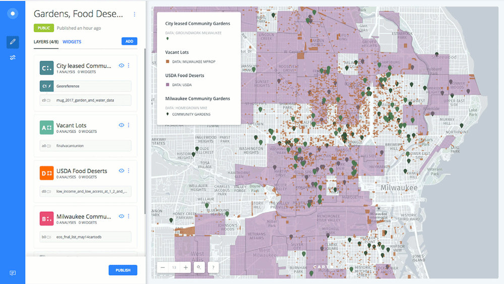
What Helps to Increase Public Participation in GIS?
Community participation in GIS through PPGIS is a worthy goal and has been applied in many studies for decades.

What are the Benefits of Landsat’s Current Free and Open Policy?
A group of researchers from different universities and government groups have published a study of how Landsat's free and open data policy has benefitted users of the programs satellite imagery products.

Using GIS to Assess Crime Risk
The use of GIS and spatial analysis has become an important tool in understanding crime patterns.

Using Machine Learning and Surface Deformation Data to Predict Earthquakes
There is no easy solution for earthquake prediction, but machine learning in particular has made forecasting far better.

GIS and Named Entity Recognition: Identifying Geographic Locations in Text
New methods in natural language processing are being developed that are merging geographic information with basic texts and human language.

USGS 3DEP Lidar Point Cloud Repository Available as an Amazon Public Dataset
Representing trillions of LiDAR points, USGS 3DEP Lidar Point data is now available as an Amazon Public Dataset.

Using GIS in Golf Course Management
GIS has a growing role in golf from managing courses to facilitating the symbiotic relationship between golf courses and environmental protection.

Updated World Magnetic Model To Be Released
An acceleration in the Earth's magnetic field has triggered an early update to the World Magnetic Model.
“Adopt A Pixel” to Help Landsat Science
Adopt A Pixel program has existed for quite some time - from 2013 - in the form of a web service which allowed users to upload geospatially tagged landscape images to complement the remote sensing collections.
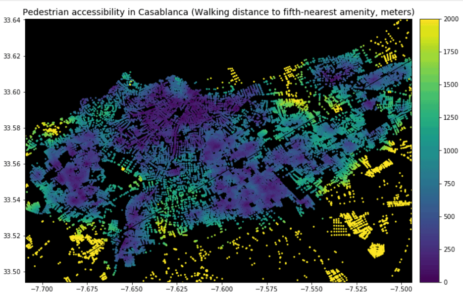
Using GIS to Analyze Pedestrian Accessibility
GIS tools to compute pedestrian accessibility are not just available to governments, academics, or companies, but are also free and open source.
GIS From the Past: CARETS
In the early 1970s, a joint pilot project between NASA and the USGS sought to test out the feasibility of integrating data from Landsat and high-altitude aircraft sensors into a regional land use database.

Who Coined the Term ‘Remote Sensing’?
While the origins of remote sensing can be traced to World War II's use of radar, sonar, and thermal detection technologies, the use of the term 'remote sensing' wasn't coined until the late 1950s.

Tracking Ocean Currents With Seabirds
A group of researchers wanted to test if drifting seabirds could offer a novel way of collecting data about sea current velocity and direction.

Mapping Where Norway is Moving
Norway is using Copernicus Sentinel-1 data to detect ground movement across the country.

How To Use the Equal Earth Projection With QGIS on the Mac
Here are a few short steps to set up the Equal Earth map projection in QGIS.
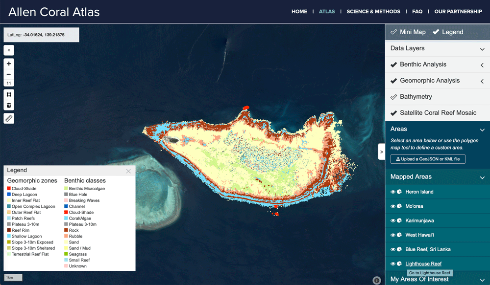
Mapping Coral Reefs
Scientists have been developing better ways to fuse data from different satellite systems and data capture, while also developing classification algorithms to better map coral reefs.

PACE: NASA’s Earth Observation Satellite to Launch in 2022
NASA’s PACE (Plankton, Aerosol, Cloud, Ocean Ecosystem) is a planned earth observation satellite with an anticipated launch in 2022.

Free Urban Planning GIS Book and Exercises
An open access book focusing on the use of GIS in sustainable urban planning and management includes six chapters containing exercises and GIS data.

Optimizing Traffic with Autonomous Vehicles and Machine Learning
Improving traffic can be achieved by incorporating geospatial technology in autonomous cars, such as sensors and external information.


Using Satellite Imagery to Track Volcanic Ash Clouds
Researchers have developed an algorithm that can distinguish between volcanic and non-volcanic clouds using high-resolution satellite imagery.

Using Machine Learning and Satellite Imagery for Street Address Generation
Facebook and MIT Labs researchers have developed a method employing machine learning and satellite images to create street addresses in regions lacking unique building addresses.
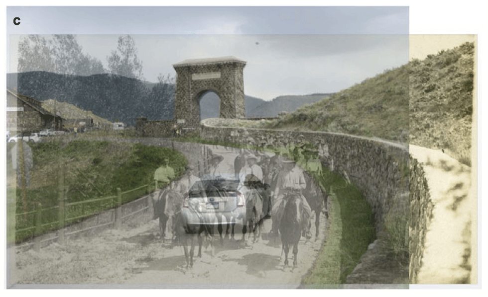
Using Ground-level Imagery to Map Landscape Change
Ground-level photographs have great value to demonstrate landscape change from a human eye-level perspective.

How to Make a Tile Grid Map Using Google Sheets
This tutorial provides instructions on how to create a tile grid map using Google Sheets.
Geospatial Data Act Passes With Industry Support
The Geospatial Data Act of 2018 (GDA) was enacted on October 5, 2018, when the President signed it as a component of the Federal Aviation Administration (FAA) Reauthorization Act (H.R. 302).