
Articles

Ensuring the Future of GIS with Geospatial Education
The U.S. government is helping to guarantee the future of GIS by investing billions of dollars in geospatial education. The ...
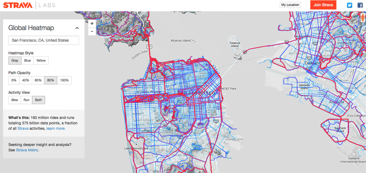
Creating a Global Heat Map from 41.5 Million Runs
Strava, a GPS running and biking application, recently released a detailed global heat map of popular routes across the globe. The map contains over 160 million activities with 375,000,000,000 data points.

Solving Field GIS Wireless Connectivity Issues with Web Apps
WebMapSolutions enhances offline GIS capabilities in the browser by integrating JavaScript widgets that extend functionality in any web app.
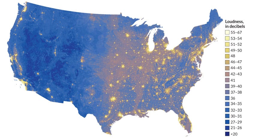
The Sound of Silence: A Noise Map of the U.S.
A map from the NPS displays the noisiest as well as the quietest places in the United States.

Using Satellite Imagery to Track the Ocean’s Acidity
The Earth’s oceans play a vital role in the health of the planet. ocean dynamics impact weather patterns, it provides ...

Maps Serve to Monitor Global Agriculture
As the world’s population grows, the amount of land available for farming is becoming a major concern. Increasing competition for ...

How Spatial Big Data Underpins Smart Cities
Underpinning any smart city program is trusted geospatial information; one single source of reliable, location-specific data.

Using a Heat Map to Show the Level of Happiness by Province in Turkey
Dogus Guler created a heat map showing levels of happiness by province in Turkey using GIS.

Geographic Spread of the Indo-European Language Family
A recent study by the Australian Centre for Ancient DNA and Harvard Medical School looked at the initial dissemination of Indo-European languages.

What are Two Main Causes of Changes to the Earth Surface?
Erosion and weathering are two forces that change the surface of the Earth over thousands and millions of years.

Geoportals
Geoportals provide a single point of access for searching for and downloading GIS data from a multitude of sources. Users looking for GIS ...

Free Field Survey Tools
With the immense leaps of cheaper data storage, cellular availability, and awareness toward open source components, the options to create ...

Geography of the International Date Line
The International Date Line is an imaginary line of longitude that divides two days and is placed at 180 degrees east or west of the Greenwich Meridian.

Using Geospatial Technologies to Save the World’s Peatlands
Rezatec has developed “Peat spotter”, a service that uses Earth Observation imagery to locate and create initial mappings of peatlands. This information is enriched with ground data collected by field agents using handheld devices.

New GISP Certification Process and Fees Announced
The GIS Certification Institute (GISCI) announced new terms and fees for its certification and recertification processes starting July 1, 2015.

The World’s Largest Mass Migration
Surrounding the Chinese New Year is a forty-day travel period known as "Chunyun," meaning “Spring Festival Transport”. Each year, Chinese officials calculate that well over 3 billion passenger trips occur during this period and overwhelms the Chinese transportation system.

Abstract Machine: Applying GIS in the Humanities
In Abstract Machine: Humanities GIS, Charles B. Travis, a senior research fellow at Trinity College Dublin in Ireland, uses case studies from history, poetry, and published works to explore out GIS analysis is used to explore and understand events in literature, history, and culture.
The Cultural Geography of Carnival Celebrations around the World
Discover how local pagan and indigenous traditions blend into unique Carnival celebrations in Brazil, New Orleans, Quebec, Italy, and Russia.
Building Better Maps for the Visually Impaired
For those of us who can see, being able to read a map is something that we take advantage of ...

Lodos (Wind)
The Lodos has been classified as a powerful south westerly wind (blowing from the south west) that can be found at regular intervals throughout the year in the Marmara Sea and Aegean Sea, as well as the Black Sea and Turkey's Mediterranean coast.

Saying “I Love You” With GPS
Aspiring Romeos around the world have been employing their GPS tools in order to give a voice to their valentines.

Esri Launches Site to Find Open Data
Esri has launched ArcGIS Open Data as a portal for users to search, download, and visualize open data: Since July 2014, ...
Paper Maps Refuse to Die in the Digital Age
In today’s era of digital maps, the use of paper maps might seem a bit antiquated. When Google Maps are ...

Economic Geography of Your Valentine’s Day Chocolate
Americans spent $700 million on chocolate treats for Valentine’s Day in 2014.


What Are the Negative Impacts of a Cinder Cone Volcano?
Cinder cone volcanoes are cone craters which are usually small and steep shaped made up of lots of little rock or ...