
Articles

Photographing and Mapping Piers
Ana Ramirez, a San Diego-based photographer, talks with Kristina Jacob about her photography project, Into The Ocean – Photos of California Piers.
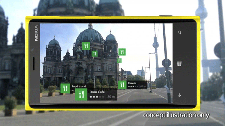
Augmented Reality and the Digital Map Revolution
Groundbreaking technology called augmented reality is affecting digital maps, changing how we find and discover the world around us.

Moraines
Moraines are the piles of dirt and rock that are displaced by a glacier as it moves across the landscape.

The 25th Anniversary of the U.S. Census Bureau’s TIGER Project
It is something that many of us take for granted every day. If we need to find directions to an ...

Conflict over Gibraltar: Who has control?
Gibraltar is a 6.5 square kilometer territory located south of the Spanish border, along the Strait of Gibraltar. The small ...

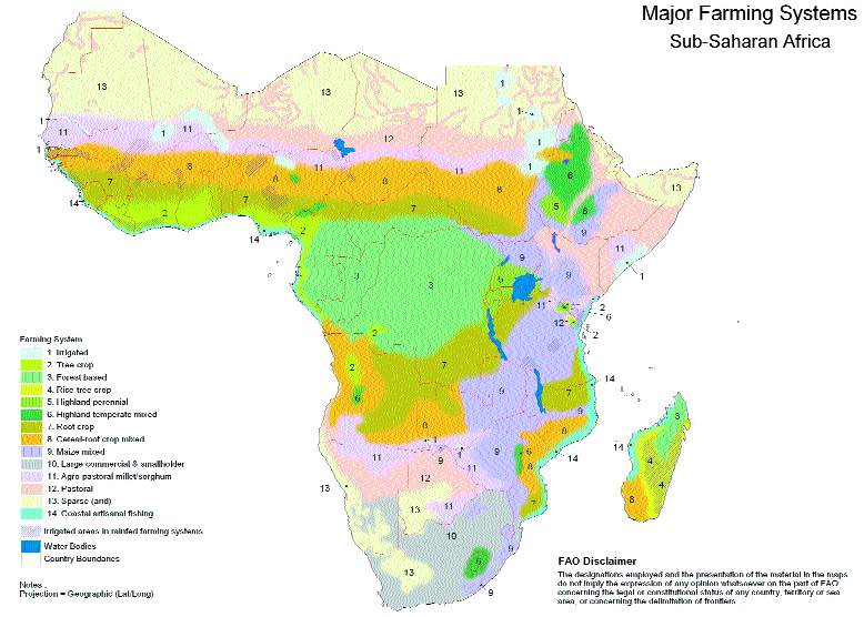
Why Development Aid Projects Must First Factor Local Culture
Why do some multi-million dollar aid projects fail? The aid itself is not generally the problem, but the lack of local, geographic specific cultural analysis in planning and implementation is most often to blame.

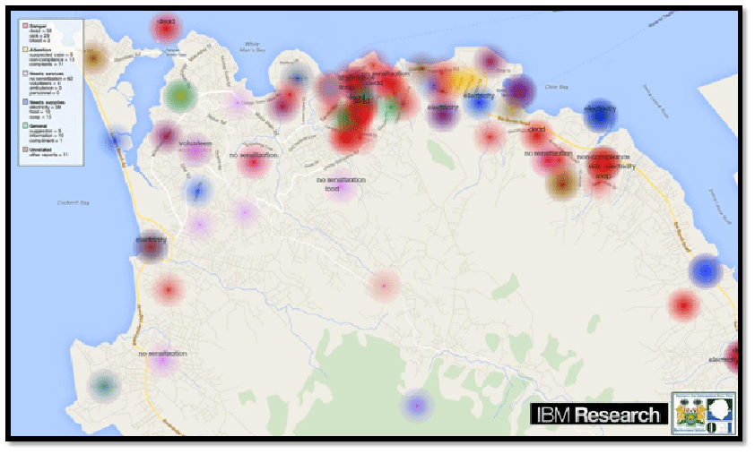
Using GPS Data to Help Cities in Emergencies
In October of 2012, Hurricane Sandy struck the East Coast of the United States causing billions of dollars in damage. ...

What is a Continental Divide?
A continental divide is seen as any natural (not man-man) boundary separating precipitation.
Eight Ways Your Geographic Skills Enhance Your Resume
Geographers or anyone with a history of geography education or practice have special skills that can enhance their resumes across nearly all career options. From GIS skills to graphic design to multiculturalism, here are eight ways to market your geography experience as viable job skills.

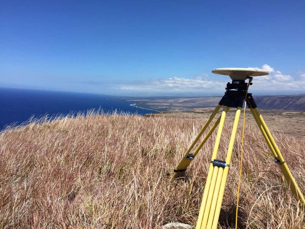
Early Efforts to Measure the Circumference of the Earth
For centuries individuals have been creating ways to accurately measure various aspects of the Earth using the tools of their times.

Where Does an Oasis Get Its Water?
Oases are interesting and vital parts of an ecosystem that can be found all around the world; along with being a unique geographical feature they provide water, shelter and shade for people passing through as well as plants and animals that live in the area of the oasis.
Fun with GPS
A multitude of games and alternatives have emerged to capitalize on the affordability of handheld GPS units.
Empowering GIS with Big Data
Analysis of Big Data in a geographic context has empowered organizations and businesses faced with huge amount of data and diverse technologies. The integration of maps with multiple layers of information tells the full story behind the data. Trends and patterns are revealed. Queries are answered and new questions are also addressed. At the same time, predictive modeling on massive datasets help drive accurate decision-making, profitability and effective resource management.
How Rapid Urbanization Threatens Human Populations: Three Effects of a Moving World
The dramatic shift of the earth’s human population to cities is not only straining urban infrastructures, but also the human population itself. Three significant human threats resulting from rapid urbanization in developing countries are increased intense agriculture from the commoditization of food, rising diabetes and heart disease rates, and brain waste of our global youth.

Using GIS to Identify Milwaukee’s Homeless Population
GIS Cloud has developed a mobile GIS and mapping app that allows for the collection of information about homeless populations in the City of Milwaukee in Wisconsin.

Mapping Carbon in the Amazon
In order to produce the most detailed carbon maps of the Amazon, researchers turned to remote sensing, specifically satellite imagery and LiDAR.
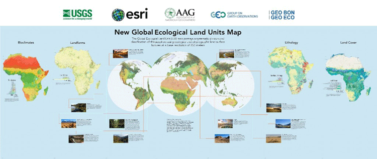
Global Ecological Land Units Map
Esri and the United States Geological Survey (USGS) have developed the highest spatial resolution ecological land units (ELUs) map of the world commissioned by the intergovernmental Group on Earth Observations (GEO).

Using Interdisciplinary World Map Activities to Connect Your Students to Other Cultures
Here are some interdisciplinary activity ideas to help children learn math, history, science, and literature while also strengthening map skills.

Why Does Finland Have So Many Lakes?
Finland, with over 187,000 estimated lakes, is known as the "Land of a Thousand Lakes".

A Case Study in Environmental GIS: Light Pollution Mapping
Geospatial consultant Marcus Hinds uses remote sensing and environmental GIS methodologies to study light pollution in the Greater Toronto Area in Canada.

GISconnector for Excel – Synchronize Data, Selections, and Filters between ArcGIS and Excel
A new tool is available called GISconnector for Excel which enables bidirectional data transfer between ArcGIS and Excel. The tool, GISconnector, also ...

How Mental Map Development Affects How We Perceive the Visual World Around Us
A new study is challenging the way scientists look at the brain’s visual and spatial orientation system.

Disconnected Editing with ArcGIS in the Browser
Matt Sheehan discusses disconnected editing for ArcGIS and the libraries that Web Map Solutions has developed to provide users with disconnected capabilities to any ArcGIS web app in the browser.

Focusing GIS Apps on the User’s Needs
Timmons Group's Lowell Ballard stresses the importance of preventing scope creep in GIS app development to keep them focused and user-friendly.

Peace Corps World Map Project: Bringing Geography Education to Unexpected Places
In 1988, a Dominican Republic Peace Corps Volunteer established the World Map Project to deliver fundamental geography education to schools and communities in the world's most remote locations.