
GIS and Geospatial Technologies
Articles focusing on the application of geographic information systems (GIS), geospatial technologies, remote sensing, LiDAR, and Global Positioning System (GPS). These technologies serve as critical tools for understanding and interacting with our physical environment. GIS allows for the mapping and analysis of spatial data Geospatial technologies refer to the various tools used to measure and analyze Earth’s lands and resources. Remote sensing provides a way to collect data from a distance, often via satellites or high-flying aircraft, and is commonly used for environmental monitoring and military applications.
GIS subcategories :
GIS Career | GIS Data | GIS Industry | GIS Learning | GIS Software | GPS | Remote Sensing | Spatial Analysis

GIS and Migrant Deaths in the United States
Spatial analysis and GIS is being used in the study of migrant deaths to not only better track routes taken but also use results from research to limit deaths and danger to migrants.
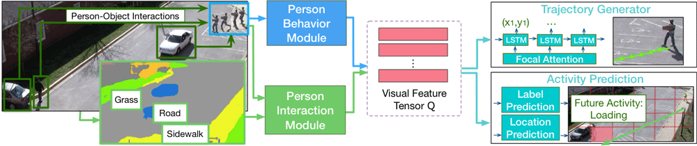
Predicting Future Movements of Pedestrians and Autonomous Vehicles
As driverless cars and motion detection technologies are increasingly integrated into our everyday lives, applications are now being developed to help with predicting movements undertaken by both pedestrians and vehicles.

What is Snapping in GIS?
Snapping involves connecting a geometric vertex or edges of one feature to another when editing a GIS dataset.

Null Island: Where Geocoding Errors Go to Live
Null Island, a fictional location at the confluence of the Equator and the Prime Meridian, is used for troubleshooting purposes as a way to flag geocoding failures.

Automated Remote Sensing of Underground Features
Below ground mapping can now better utilize remotely sensed data to create more accurate maps.
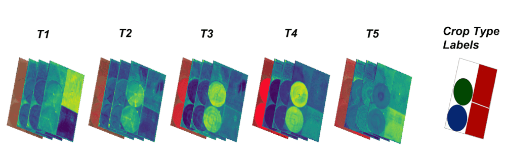
Open Repository for Geospatial Training Data Released
Radiant Earth has launched Radiant MLHub, a cloud-based open library for training geospatial data used by machine learning algorithms.

There are Four Trillion Measurements in this Global Sea Surface Temperature Dataset
Researchers have compiled an enormous global dataset with over four trillion satellite-based measurements of sea surface temperature.
MERIT Hydro: A High-Resolution Global Hydrography GIS Dataset
Researchers have developed a high-resolution GIS dataset of river systems using remotely sensed data and OpenStreetMap data.

EarthPy: Python Package for Plotting and Working with Spatial Data
A Python language spatial package, called EarthPy, has been released for free download for working with GIS data.

Mapping Plant Stress With Remote Sensing
NASA researchers are able to map out plant stress using a remote sensing from ECOsystems Spaceborne Thermal Radiometer Experiment on Space Station, or ECOSTRESS.

Map of Geospatial Companies Around the World
Christoph Rieke has assembled a growing list of commercial geospatial companies with offices located all around the world.

Learn How GIS and Earth Observation Can be Used to Support the United Nations Sustainable Development Goals
Earth Observation and GIS technologies have a huge impact on both monitoring the implementation of the United Nation's sustainable development goals.

Creating a Spatial View of the Brain
Mapping small scale but complex organs such as the human brain is requiring new technologies and spatial modeling to be developed.

24 Days of QGIS Tips
Using the #24daysofqgis hashtag, North Road, a geospatial company based out of Australia, will be tweeting out a QGIS tip or trick for 24 days starting on December 1.

Artificial Intelligence Was Used to Discover a New Nasca Line
Researchers tested out the use of artificial intelligence to assist with finding new Nasca lines.

Understanding LiDAR Technologies
This article presents insights from the new IDTechEx report titled “Lidar 2020-2030” IDTechEx report.

I’m a…. the GIS Profession in One Word
How do you describe GIS as a profession in as few words as possible?

The Critical Role of GIS in NG9-1-1
Drew Fioranelli, GISP, Public Safety GIS Market Maker, and Annie Cahill, Public Safety GIS Technical Manager with DATAMARK, discuss the history of 9-1-1 infrastructure as well as the foundational role of GIS and GIS professionals in the transition to Next Generation 9-1-1 (NG9-1-1) .
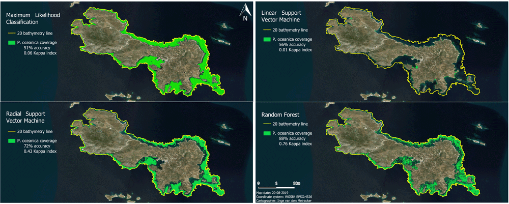
Mapping the Subsea Forests of the Mediterranean
Inge van den Meiracker writes about her research internship in Greece where she modeled and mapped the seagrass distribution in the Southeast Aegean Sea using sonar data, remote sensing techniques, and GIS.

PennVet Uses GIS to Identify Disease Hot Spots
Dr. Meghann Pierdon with the University of Pennsylvania’s School of Veterinary Medicine has developed a secure website that uses GIS to map out the incident of diseases among pigs or birds.

New Report Values Economic Benefits of Landsat Archive at $3.45 billion
A newly released report from the USGS has estimated the 2017 domestic and international economic benefits of Landsat imagery to be $3.45 billion.

Using GPS to Improve the Accuracy of Drone Mapping
By improving the precision of the GPS devices on UAVs, it is now possible to create much more accurate maps without needing to physically visit the area in order to ground truth.

How to Use GIS to Make a Lego Map
Depending on the GIS software you want to use, there are a few different ways to create a Lego-style map.

Portable GIS
Portable GIS is a collection of open source GIS software applications and tools that can be run from a portable drive.
Making Finding Geographic Information Easier: SpatioTemporal Assets Catalogs
SpatioTemporal Assets Catalogs (STAC) provides a common set of search terms so that geospatial information can be found and indexed easily.

Online Landslide Inventory Mapping Tool
The USGS has launched an online web map that compiles existing United States landslide data into a searchable tool called the U.S. Landslide Inventory Map.