
GIS and Geospatial Technologies
Articles focusing on the application of geographic information systems (GIS), geospatial technologies, remote sensing, LiDAR, and Global Positioning System (GPS). These technologies serve as critical tools for understanding and interacting with our physical environment. GIS allows for the mapping and analysis of spatial data Geospatial technologies refer to the various tools used to measure and analyze Earth’s lands and resources. Remote sensing provides a way to collect data from a distance, often via satellites or high-flying aircraft, and is commonly used for environmental monitoring and military applications.
GIS subcategories :
GIS Career | GIS Data | GIS Industry | GIS Learning | GIS Software | GPS | Remote Sensing | Spatial Analysis

Free GIS, Analytical, and Programming eBooks from Springer
If you're looking for free digital books covering GIS, analysis, and programing to improve your geospatial skills, Springer has eBooks you can download.

New Satellite Technologies to Monitor Volcanoes and Earthquakes
One relatively new satellite is a small satellite system called the CubeSat Imaging Radar for Earth Sciences (CIRES).

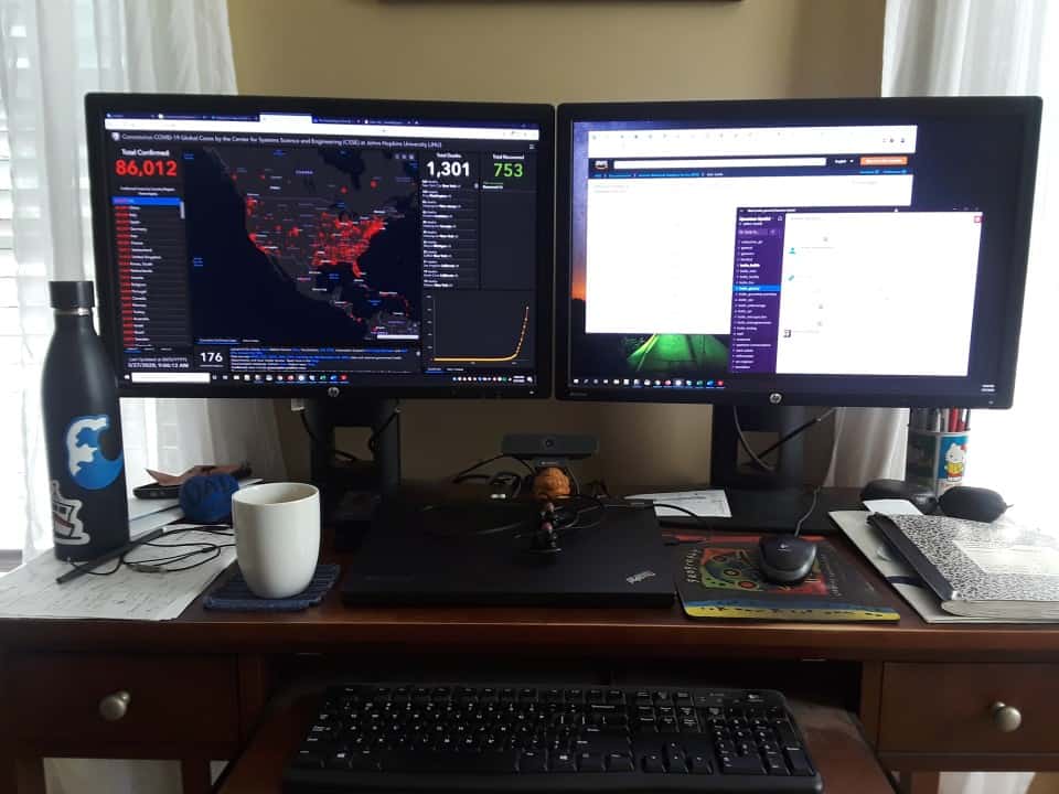
Using Location Data to Map People’s Movements, Social Distancing Efforts, and the Spread of COVID-19
As the COVID-19 pandemic continues, mobility data is being used to track and map out social distancing compliance and track the spread of the coronavirus.
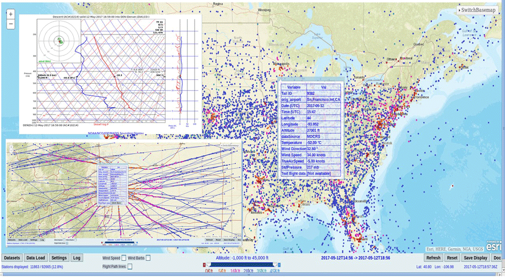
How Weather Forecasting is Affected by Coronavirus-Related Flight Cancellations
Grounded flights due to the coronavirus pandemic is resulting in far fewer aircraft weather observations and less access to repair remote weather stations.

Computer Vision in the Time of the Coronavirus Outbreak
Computer vision is emerging as a promising set of techniques such as enabling rapid detection of COVID-19 and the better monitoring of social distancing practices among people.
Tips for Leading a Remote Team during Covid-19
Jeffrey Skahill with Quantum Spatial shares some strategies he uses to successfully lead a remote team.
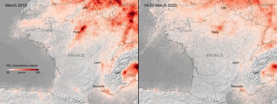
Mapping Changes in Air Pollution During the Coronavirus Pandemic
Satellite imagery also confirms many countries are seeing a strong downward trend in air pollution during the coronavirus outbreak.

Can GPS Work on the Moon?
NASA researchers found that existing GPS satellites can provide navigational signals to the moon, aiding astronauts in future lunar missions.

Geolocation Data, Geofencing Warrants, and Crime
With most adults carrying mobile devices that have GPS tracking capabilities, mapping our movements has never been easier.

Open Access Novel Coronavirus Data
A newly published article in Nature's Sci Data decribes how epidemiologists collected and curated individual-level novel coronavirus data from a variety of national, local, and news sources.
How to Volunteer Your GIS and Cartography Skills
Those with GIS and cartography skills that want to volunteer to help out can do so remotely with these calls for actions as mapping non-profits respond to the coronavirus pandemic.

GIS and Cartography Material Available for Online Teaching
Several institutions and professors have offered up readily available online resources that can be used to virtual teach cartography and GIS courses.
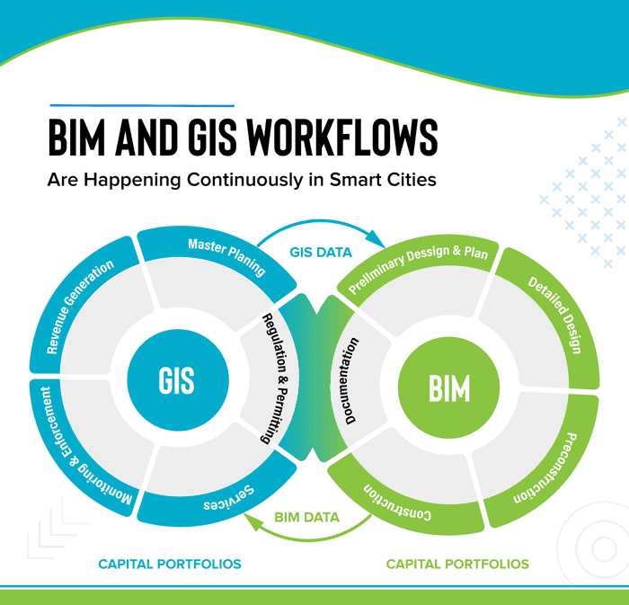
GIS and BIM Integration in Infrastructure Design and Construction
The latest advancements in geospatial services are making changes in the AEC industry. BIM for infrastructure design helps improve the workflow and saves valuable data through every stage of the process. Read about how GIS and BIM integration will transform these industries.

Access Open GIS Data for Almost 11 Million Trees with OpenTrees
Developed by Steve Bennett, OpenTrees.org lets you visualize and download GIS data for almost 11 million city and park trees around the world.

Updated Global Elevation Data Released by NASA
A new global digital elevation model (DEM) has been released by NASA.
Geotargeting by Advertisers and Government Agencies
Geotargeting by advertisers, which is the practice of sending advertisement based on location, has gained increased importance for companies marketing their product in recent years.

Mapping the Entire Surface of the Earth with LiDAR
A project called the Earth Archive plans to use Light Detection And Ranging (LiDAR) to map the entire surface of the Earth.

How GIS is Used in All Phases of Emergency Management
In this guest article, Brian Sekita discusses how GIS is vital to all phases of the emergency management process.

Mapping the Universe
New satellite technology achieved in in the last decade are helping scientists to more accurately map the universe.

Using GIS to Map and Track Vandalism
GIS is being used to better understand current and potentially future patterns of vandalism.

Using GIS to Assess the Impact of Electric Cars
GIS and spatial analysis may help find some practical solutions for electric vehicle charging.
Using GIS to Assess Urban Tree Canopy
The University of Vermont Spatial Analysis Lab used spatial analysis to map out how the city of Philadelphia's tree canopy changed between 2008 and 2018.

Satellites Give Detailed Insights into Climate Sciences
The European Space Agency has recently released a report entitled ‘10 New Insights in Climate Science’.

How to Add Leader Lines to Labels in QGIS
The release of QGIS version 3.10 brought with it the native capability to add leader lines to labels.

Cloud-based Geospatial Analysis
We will see more migration of spatial and GIS work to cloud-based platforms in the near future.

GIS Data of the Moon’s Geology
The USGS has released GIS data from its new Unified Geologic Map of the Moon.