
GIS and Geospatial Technologies
Articles focusing on the application of geographic information systems (GIS), geospatial technologies, remote sensing, LiDAR, and Global Positioning System (GPS). These technologies serve as critical tools for understanding and interacting with our physical environment. GIS allows for the mapping and analysis of spatial data Geospatial technologies refer to the various tools used to measure and analyze Earth’s lands and resources. Remote sensing provides a way to collect data from a distance, often via satellites or high-flying aircraft, and is commonly used for environmental monitoring and military applications.
GIS subcategories :
GIS Career | GIS Data | GIS Industry | GIS Learning | GIS Software | GPS | Remote Sensing | Spatial Analysis

OpenStreetMap: One of the World’s Largest Collaborative Geospatial Projects
OpenStreetMap is a community project with the goal of mapping the world using a crowdsourcing, collaborative method.
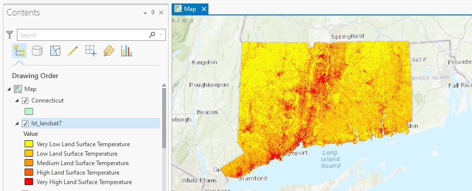
How to Use ArcGIS Pro to Calculate Land Surface Temperature (LST) from Landsat Imagery
This ArcGIS Pro tutorial utilizes spatial data science and remote sensing techniques to calculate land surface temperatures using Landsat imagery.
A Look at Google Earth Engine
In a MapScaping podcast episode, Quisheng Wu discusses Google Earth Engine how it allows users to share and upload their own geospatial analyses.

View From Space: Stuck in the Suez Canal
Satellites have captured imagery of the Ever Given which is currently stuck in the Suez Canal.

How to Use ArcGIS Pro to Assess Landslide Susceptibility
This tutorial explains how landslide susceptibility can be assessed using ArcGIS Pro.

Using ArcGIS Online to Manage Content
With the Item Report Dashboard from GEOACE, you can use out-of-the-box tools in ArcGIS Online to manage content within an organization.

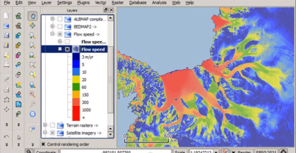
Synthetic-Aperture Radar (SAR), Earth Observation, and Mapping
Synthetic-Aperture Radar (SAR) is becoming more widely available and increasingly part of Earth observation satellites.

GIS Data for California Public Schools
California School Campus Database (CSCD) offers a GIS dataset that contains all of the public school locations from K-12 grades for California.

From GIS Analyst to Software Engineer
In a MapScaping podcast, Dan Mahr talks about how he was able to transition to a software engineer, but still use his GIS skills to benefit his career.

Using GIS to Explore Mars
Esri’s Explore Mars site allows you to explore the surface of Mars and make some basic geospatial measurements.

Why the ‘One Map Fits All’ Approach Doesn’t Fit All
A custom map stack can help leverage maps in new exciting ways.

Mapflow.ai — New Buildings Model and Kepler.gl Implementation
GeoAlert provides an overview of some of the features of its new Mapflow application.

Monitoring Vegetation Regrowth After Fire With Remote Sensing
Synthetic-aperture radar (SAR) is being used to map post-fire vegetation recovery.

Building a 4D World
VoxelMaps describes how they are creating a global 4D map that can capture outdoor and indoor spaces at different spatial and temporal scales.

Highlight Your Skills with a GIS Portfolio
A GIS portfolio is a way to digitally present GIS projects and maps that you have created.

New GIS Dataset on the Interconnection Between Urban Centers and Rural Areas
A freely downloadable GIS dataset – the Urban–Rural Catchment Areas (URCAs) – shows the diversity of urban-rural systems worldwide.

Mentoring, Leadership, and Building Skills in the Geospatial Community
Leaders in the geospatial community can help to foster key skills through mentoring and developer a stronger community.
The “Bystander Effect” With Crowdsourcing GIS Data
A recent research article found that users are less inclined to contribute to crowdsourced geospatial sites like OpenStreetMap and Waze if they know others are already contributing.
The Past, Present, and Future of GNSS
The Global Navigation Satellite System (GNSS) has emerged as the standard navigation system that provides global positioning for devices we use every day.

Atlas of the Human Planet: Free GIS Data and Tools
The Atlas of the Human Planet 2020 provides GIS Data for research, policy, and action that can be used to document the presence of humanity on Earth.
Quantarctica – Free GIS Data for QGIS
Quantarctica is a collection of freely downloadable GIS data for Antartica.

Mapping the Ocean Floor by 2030
A MapScaping podcast episode with NOAA's Samuel Greenaway discusses how mapping the seafloor will be a major challenge this decade.

Mapping Ground Subsidence
Synthetic Aperture Radar (SAR) can map subtle differences in the rates of subsidence.

NextBillion AI Solves HyperLocal Geospatial Infrastructures To Advance Mapping Ecosystems
NextBillion AI builds AI-based geospatial infrastructures to strengthen logistics, transportation, and supply chain services throughout the ecosystem.

The Geography Behind Being a GIS Professional
In a recent GIS podcast, Sarah Taigel discusses how being a professional geographer can provide key advantages to using GIS analysis.

Augmented Reality and Computer Vision in Navigation
The use and field of AR and computer vision are rapidly changing in how these technologies are being used in navigation.