
Caitlin Dempsey

Glaciers in the Antarctic Peninsula are Moving Faster During the Summers
Antarctic Peninsula glaciers are speeding up: Analysis of 10,000+ satellite images from 2014-2021 shows increased seasonal velocity in 105 glaciers.

Changes in Ice Cover on the Great Lakes
Ice cover on the Great Lakes varies annually depending on factors such as air temperature, wind, and lake depth.

Why are Most Meteorites Found in Antarctica?
More meteorites have been found in Antarctica than all other continents combined. Why is that?

Europe’s Longest Road and Railway Bridge
The Øresund Bridge connects Denmark and Sweden, spanning the Øresund Strait with a 16-kilometer-long bridge-tunnel.

Universal Transverse Mercator (UTM) Coordinate System
UTM is a precise, grid-based coordinate system ideal for regional mapping and navigation, utilizing 60 zones to minimize distortion.
Real-time Satellite Tracking
N2YO.com is an online service that offers satellite tracking and information in real-time.

What is a Closed Lake?
Closed lakes are bodies of water that do not drain into an ocean or river.

GIS 101: Learn About GIS
This GIS 101 page is the launch page for accessing information about GIS and geospatial technologies on GIS Lounge.

Type of Map Perspective: Bird’s Eye
Bird's-eye maps are created from an elevated perspective, showing an area as seen from above.

A to Z Geography: Alabama
Here is an alphabetical list of words that relate to Alabama and its geography.

Geography of Bees
Bees, crucial pollinators, inhabit every continent except Antarctica. With over 20,000 species, they face threats from climate change and habitat loss.

Wonderful Words to Describe How We Experience Geography
There are some unique words to describe some of how we experience the world around us.
Women in GIS Networking Groups
Web sites with information specifically regarding peer support for women in GIS.

Haboobs in the United States
Haboobs, also known as convectively-driven dust storms, are intense, large-scale dust storms that occur in arid regions in the United States.
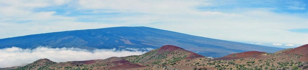
Geography Facts About the World’s Largest Active Volcano
Hawaii's Mauna Loa is the world's largest subaerial volcano as well as the world's largest active volcano.

Lake Effect Snow
Lake effect snow can occur when dry, cold air moves across a vast lake with warm waters, resulting in a snowfall event.

Walking Cane Maps
Walking cane maps, first created in 1893, featured retractable maps in cane handles. These souvenirs combined practicality with novelty.

Triple Divides in the United States
A triple divide is a point on Earth where water from that location can potentially travel into three different watersheds.

Dams in the United States
There are dams in all 50 U.S. states and over 91,000 dams in all.

The Map Myth of Bermeja Island
For hundreds of years, cartographers mapped Bermeja Island off the coast of Mexico, but no evidence has been found to prove its existence.
Should Maps Include a North Arrow? Exploring the Debate
Do all maps need a north arrow?

Geography Definitions Related to Water
Listed here are geography terms related to water bodies such as lakes, rivers, and oceans.

Open Source GIS and Freeware GIS Applications
There are many open source GIS and web mapping applications to choose from.

Heat Maps in GIS
Heat mapping, from a GIS perspective, is a method of showing the geographic clustering of a phenomenon.

What is the Difference Between GIS and Geospatial?
There are differences in what the terms GIS and geospatial mean.
Free GIS Books
Most of these free GIS books are available in downloadable PDF format and can be read from a computer or on an eBook reader.