
Caitlin Dempsey
Should Maps Include a North Arrow? Exploring the Debate
Do all maps need a north arrow?

Geography Definitions Related to Water
Listed here are geography terms related to water bodies such as lakes, rivers, and oceans.

Open Source GIS and Freeware GIS Applications
There are many open source GIS and web mapping applications to choose from.

Heat Maps in GIS
Heat mapping, from a GIS perspective, is a method of showing the geographic clustering of a phenomenon.

What is the Difference Between GIS and Geospatial?
There are differences in what the terms GIS and geospatial mean.
Free GIS Books
Most of these free GIS books are available in downloadable PDF format and can be read from a computer or on an eBook reader.

Which States are Part of New England?
New England is a geographic region in the northeastern tip of the United States that contains six states.
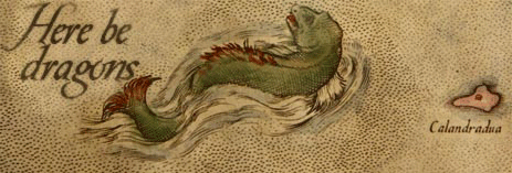
The Map Myth of Here Be Dragons: The Facts and Fictions of Mapmakers
What lies at the edge of the known world? Cartographers over the ages have used different ways of showing the unknown.

Notable Cartographers and Their Maps
Notable cartographers have shaped our understanding of the world with their maps, offering remarkable contributions throughout history.

Earth at Night
Nighttime lighting is when the effect of humans on the environment is especially pronounced.

Visual Geography: the Shape of Land Near the Oceans
A visual dictionary of geography words that describe the shapes of land near ocean water.

How to Add Data from ArcGIS Online to QGIS
Adding data from an ArGIS Online Map Service or Feature Service into a QGIS map project is fairly easy and quick in most instances.

Landsat: Longest Running Earth Imagery Program
With satellites in orbit since 1972, the Landsat program is the longest running Earth observation program.

Biogeography Definitions
Here are some common terms in biogeography, a field of geography that studies the distribution of species.

A Roundup of Geospatial Podcasts
Here's a list of GIS / geospatial podcasts you can listen to.

The Largest Delta in the Arctic
The Lena Delta is a significant wildlife refuge and the largest delta in the Arctic.

Understanding Direction Based on the Sun
This lesson plan introduces the concept of direction to young children by using the location of the Sun in order to understand where east, west, north, and south are located.

Waterfalls That Flow Into the Open Ocean
Waterfalls that flow directly into the ocean are known as tidefalls, a rare natural phenomenon where freshwater meets the sea.

Triple Dip La Niña Event
Current predictions have given La Niña a strong probability of persisting into 2023, making it a triple dip event.

Where are Wild Turkeys in California From?
The wild turkeys that roam California were originally introduced from Texas.


Geographic Coordinate Systems
Geographic coordinates are defined as being north or south of the Equator and east or west of the Prime Meridian.
How to Add Latitude and Longitude as a CSV File in QGIS
This quick QGIS tutorial takes you through the steps of how to add a CSV file with latitude and longitude coordinates.

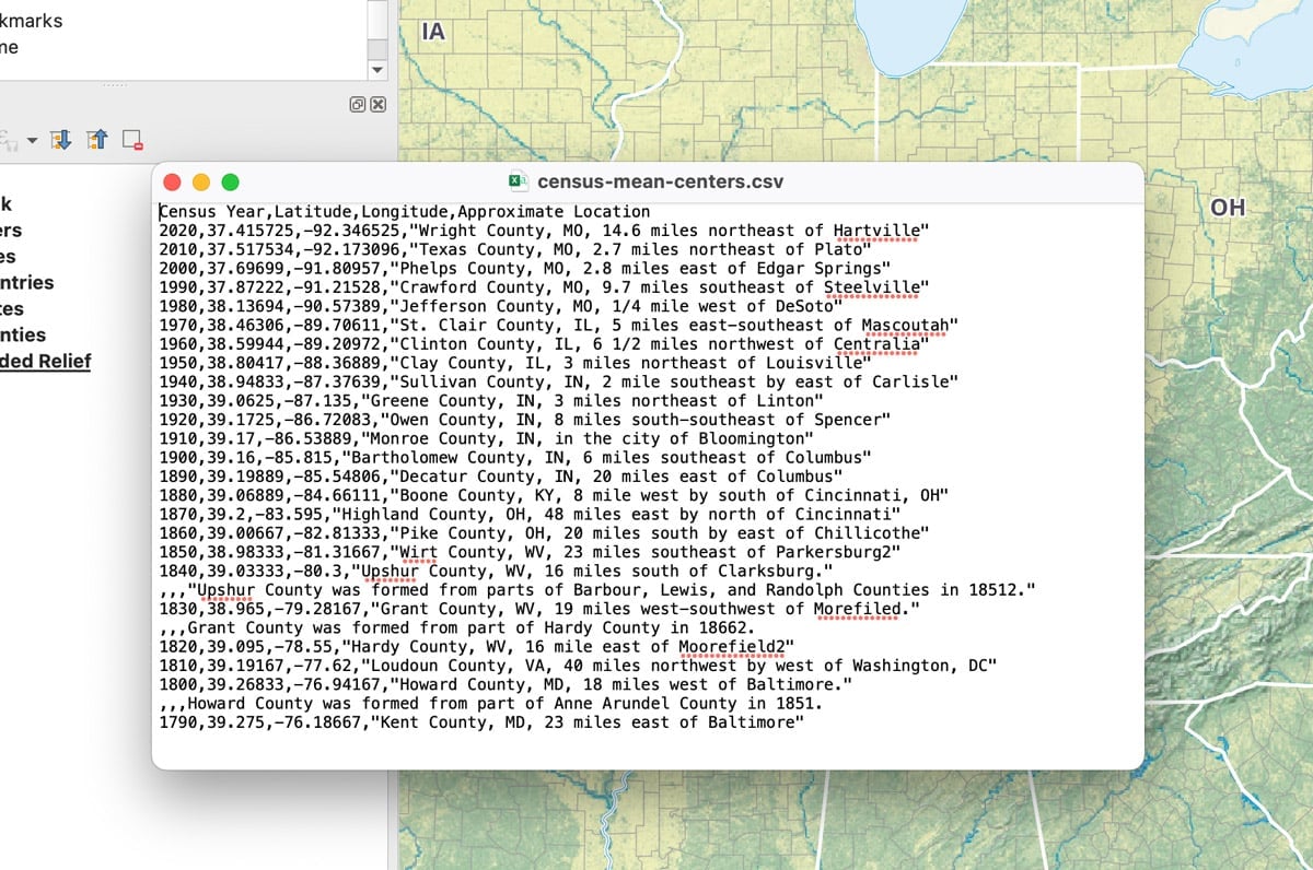
Population Center of the United States
Every ten years, the U.S. Census Bureau maps out the mean and median population centers in the United States.

Synanthropes at a Horse Stable in Northern California
Synanthropes are wildlife that benefit from living near humans.

Continental vs. Contiguous United States: Key Differences Explained
Continental and contiguous are two geographical words used to describe parts of the United States.