
GIS and Geospatial Technologies
Articles focusing on the application of geographic information systems (GIS), geospatial technologies, remote sensing, LiDAR, and Global Positioning System (GPS). These technologies serve as critical tools for understanding and interacting with our physical environment. GIS allows for the mapping and analysis of spatial data Geospatial technologies refer to the various tools used to measure and analyze Earth’s lands and resources. Remote sensing provides a way to collect data from a distance, often via satellites or high-flying aircraft, and is commonly used for environmental monitoring and military applications.
GIS subcategories :
GIS Career | GIS Data | GIS Industry | GIS Learning | GIS Software | GPS | Remote Sensing | Spatial Analysis
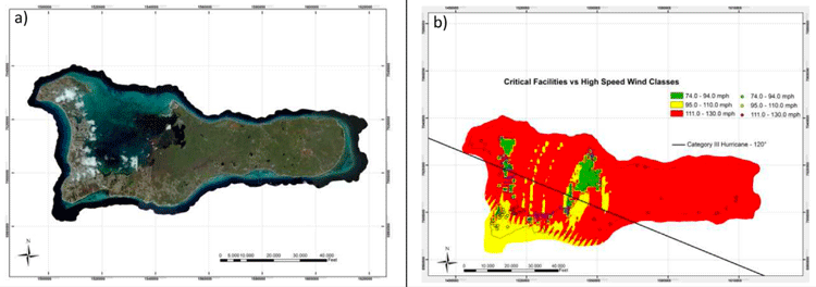
Predicting and Assessing the Impact of Hurricanes with GIS
GIS has become an important tool in assessing the risk of hurricanes and estimating the impact of damage that they may cause.

Cost Distance and GIS
GIS can be used for cost distance mapping by factoring a variety of variables, ranging from economic, social, cultural, environmental, or other barriers to analyze the ‘cost’ in travel or movement.

Introduction to Density Mapping With GIS
Density mapping shows where points or lines are concentrated. GIS tools like ArcGIS and QGIS provide point density analyses.

Using GIS to Help Locate Missing Persons
Andy Berry, Vice President EMEA at Pitney Bowes Software, discusses the important role of geospatial data as applied by the New South Wales police in Australia, in Search and Rescue.

The USGS Landsat Analysis Ready Data (ARD) Program
Landsat data, referenced with WGS84 and provided as GeoTIFF, can be accessed from EarthExplorer for the contiguous US, Alaska, and Hawaii.

Entire National Spatial Reference System (NSRS) to be Modernized in 2022
In 2022, the National Spatial Reference System (NSRS) is scheduled to be modernized, with new reference frames replacing the NAD 83 system and the North American Vertical Datum (NAVD) 88.

Mapping Global Forest Biomass
The European Space Agency is using satellite radar data collected from their satellites to measure how much wood is in the world’s forests globally.

Creating a Time Series Visualization of Two Decades of Changes in a Glacier
NASA has created a time series visualization of Greenland’s Helheim Glacier using 20 years of data from radar, lasers, and high-resolution cameras.

Mapping Noise Pollution
As noise pollution continues to be a major issue for expanding urban areas, novel geospatial technologies have been deployed to better monitor and measure noise pollution.
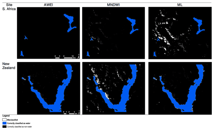
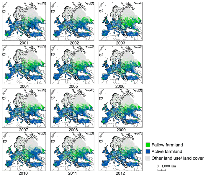
Automated Land Cover Maps
Automating the generation of land cover maps from satellite imagery is becoming easier due to learning-based algorithms improving the understanding of signal data.

Methods for Creating Cloud Free Satellite Imagery: Sentinel 2
Nearly 70% of the globe is covered by clouds at any given time. Several methods have been developed to remove cloud cover from satellite imagery.

GIS and Machine Learning for Habitat Protection
With gains in computational power and accessibility to off the shelf models, often used in commercial or open source software, applying machine learning techniques with GIS has become far easier for conservation and habitat specialists.

Open Data Site Established for Hurricane Harvey
An open data site has been set up to house GIS data from authoritative sources relating to Hurricane Harvey.

Researchers are Using Machine Learning to Better Predict Weather Patterns
The enormous amount of data from Earth-observing satellites is pushing researchers to use machine learning to mine the information and improve climate models.
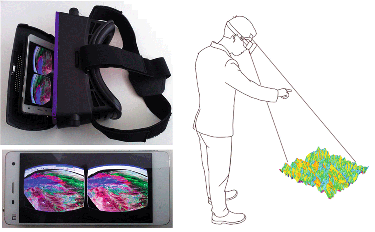
GIS and Virtual Reality
The integration of virtual reality (VR) with GIS is gaining traction in various areas such as urban planning and education.

How LiDAR is Being Used to Help With Natural Disaster Mapping and Management
Michael Shillenn, vice president and program manager with Quantum Spatial outlines three projects where LiDAR data from the USGS 3D Elevation Program (3DEP) has been used to assist in planning, disaster response and recovery, and emergency preparedness.
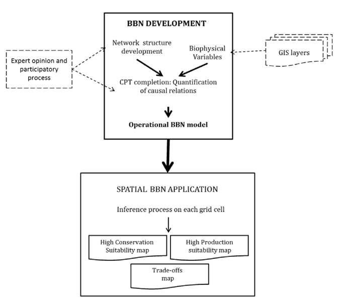
GIS and Bayesian Belief Networks
Bayesian belief networks (BBN) and GIS can be used as decision aides to give an idea of probability of events unfolding.
View Arctic Elevation Data with ArcDem Explorer
ArcticDEM is a project that is working to produce digital elevation models of the Arctic in order to see how topographical changes are occurring over time, such as the rate at which glaciers are receding.

Digitizing Errors in GIS
Digitizing in GIS is the process of converting geographic data either from a hardcopy or a scanned image into vector GIS data by tracing the features. Explained in this article are the types of common digitizing errors found when creating geographic data within GIS.

Where is Open Source GIS Going?
Mark Altaweel discusses the growth and direction of open source GIS tools and software in this opinion piece.
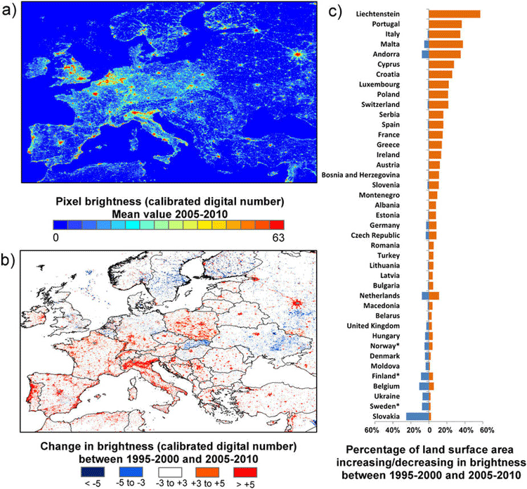
How Geospatial Technologies Are Being Used to Study Light Pollution
Spatial technologies, including remote sensing and GIS, have been used to monitor light pollution and its associated degradation effects.

Jason-2 Satellite to Help Improve Maps of Sea Floor
Jason-2 will be collecting data about the sea floor every 5 miles, which will be used to create a high-definition estimate of the average surface height of the ocean in various places around the globe.
Measuring Vegetation from Satellite Imagery with NDVI
Normalized difference vegetation index (NDVI) is a remote sensing technology that measures vegetation kinds and growth by measuring vegetation fingerprints.

GIS and Stratified Heterogeneity
A method to measure uneven distribution of landscape or population features in a given space is stratified heterogeneity.

GIS and Digital Humanities
GIS significantly influences digital humanities with a spatial focus, increasingly important for various humanities scholars.

OpenRouteService’s ‘Quiet Routing’ Creates a Less Stressful Route for Pedestrians
Prof. Dr. Alexander Zipf introduces OpenRouteService's experimental routing option 'Quiet Routing' which guides pedestrian travel around noisy urban areas.