
GIS and Geospatial Technologies
Articles focusing on the application of geographic information systems (GIS), geospatial technologies, remote sensing, LiDAR, and Global Positioning System (GPS). These technologies serve as critical tools for understanding and interacting with our physical environment. GIS allows for the mapping and analysis of spatial data Geospatial technologies refer to the various tools used to measure and analyze Earth’s lands and resources. Remote sensing provides a way to collect data from a distance, often via satellites or high-flying aircraft, and is commonly used for environmental monitoring and military applications.
GIS subcategories :
GIS Career | GIS Data | GIS Industry | GIS Learning | GIS Software | GPS | Remote Sensing | Spatial Analysis

Transforming Satellite Imagery Classification with Deep Learning
Deep learning has a potential to transform image classification and its use for the spatial sciences, including GIS.

GIS Certification versus Certificate Programs
GIS certification and certificate programs are two similarly named yet different markers of a person's GIS education and skills achievements.

Monitoring Algal Blooms with Remote Sensing
Given the importance of knowing how blooms affect aquatic life, remote sensing techniques using a variety of available imagery have been developed.
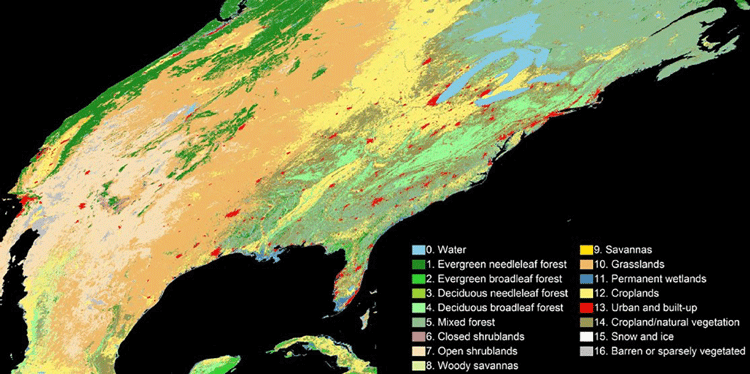
An Algorithm to More Accurately Classify Land Cover Using Landsat Imagery
Hankui Zhang, from South Dakota State University, has developed a new classification technique that combine satellite images from MODIS and Landsat.
Holographic GIS
As mobile and handheld devices increasingly use virtual reality and augmented reality applications, GIS has been incorporated to deploy spatial databases that apply holographic capabilities.
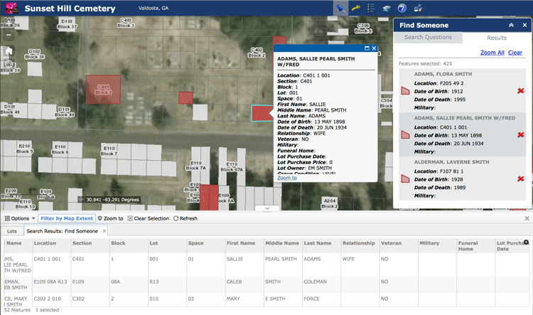
Using GIS to Analyze the Geography of Cemeteries
In addition to studying historic burial sites, GIS has also been shown to be effective in managing modern cemeteries, particularly as space becomes an increasing problem in densely populated regions.

How to Add a Map from Mapbox to QGIS
This tutorial will show you how to take a map style you have created in Mapbox and load it into a QGIS session.

Collaborative Documentation of Online GIS Applications
Olivia Harne discusses the need for adequate documentation by project members when developing online GIS applications.

LiDAR: Light Detection And Ranging
LiDAR systems are used to collect high resolution topographic and bathymetric data.

Developing Damage Proxy Maps from Satellite Data
Satellite data is being used to create Damage Proxy Maps to assess changes in an area as the result of natural disasters like Hurricane Maria in Puerto Rico, and the wildfires that have hit Northern and Southern California.
GIS and Gerrymandering
GIS can be used to detect and also assist in gerrymandering when developing new district maps.

Free GIS Data Viewers
Free data viewers for a variety of GIS data formats. These viewers allow you to display geographic data as well as perform some basic GIS functions.

How to Geocode Addresses Using QGIS
If you have a CSV formatted file containing addresses, you can take advantage of QGIS to map out those addresses. This article contains step by step instructions for geocoding addresses using QGIS.

GIS and Territorial Disputes
The use of GIS for mapping territorial disputes has played both a positive and negative role in resolving these disputes.

When Predictions Match Reality: The Power of LiDAR for Flood Warnings
LiDAR data is being used to develop highly accurate elevation-enabled flood inundation mapping in advance of major storms in North Carolina.

Watch Landsat 8 Imagery Acquisition in Near Real-time
The FarEarth Global Observer offers visitors the opportunity to view near-live streams of Landsat 8 imagery being acquired in near real-time.

Seafloor Mapping Techniques
Today, seafloor mapping is essentially a form of remote sensing that uses similar concepts and applications to satellite-based systems, albeit adapted to the complex environment of the oceans.

GIS File Formats
Listed here are some of the more common file formats along with associated file extension for GIS file types.

Is the Newly Revised Geospatial Data Act Worth Supporting?
Anthony Calamito, Chief Geospatial Officer of Boundless, explains why Boundless stands behind the new Geospatial Data Act.

How to Save a Selection as a New File Using QGIS
Learn how to save a selection from a GIS dataset to a new GIS file using QGIS with this quick video tutorial.
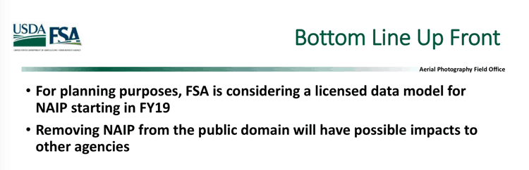
NAIP Aerial Imagery Might be Moved from the Public Domain to a Licensing Model
The Farm Service Agency (FSA) is considering moving its National Agriculture Imagery Program (NAIP) from a free aerial imagery service to a licensing model starting the 2019 fiscal year.
The Rise of Femtosatellites
Femtosatellites, very small-scale satellites (weighing less than 100 grams / 0.22 lbs), have developed over the last fifteen years thanks to advances in nanotechnology.

Rapid Response Monitoring Tools
With rapid data access, new vehicles and tools that can go almost anywhere (e.g., such as unmanned aerial vehicles), and more efficient computing, we are witnessing an age of rapid response monitoring that addresses environmental and social problems as they develop.

UAVs, GIS, and Ecology
With the relatively cheap price and increasing effectiveness of unmanned aerial vehicles (UAVs), often called drones, we are seeing much more accurate estimates and understanding of ecological change.

Will 2017 be Remembered as a Stellar Time for Earth Observation?
Joe Francica, Managing Director Location Intelligence Solutions with Pitney Bowes discusses the growth and direction of Earth Observation satellites.

Monitoring Air Pollution with Sentinel-5P
Sentinel-5p will be one of the first satellites that provides high resolution pollution monitoring and will provide a large data capture that enables daily and even hourly monitoring.