
Articles

The Largest Delta in the Arctic
The Lena Delta is a significant wildlife refuge and the largest delta in the Arctic.

Understanding Direction Based on the Sun
This lesson plan introduces the concept of direction to young children by using the location of the Sun in order to understand where east, west, north, and south are located.

Mapping Oil Slicks With Satellite Imagery
Sentinel-1 synthetic aperture radar (SAR) satellite data has been used in a study to map oil slicks.

Waterfalls That Flow Into the Open Ocean
Waterfalls that flow directly into the ocean are known as tidefalls, a rare natural phenomenon where freshwater meets the sea.

Triple Dip La Niña Event
Current predictions have given La Niña a strong probability of persisting into 2023, making it a triple dip event.

Geography is Destiny: Britain and the World | Book Review
Ian Morris provides a most-useful survey history of Britain from geologic time to the present centered around three maps.

Where are Wild Turkeys in California From?
The wild turkeys that roam California were originally introduced from Texas.


Geographic Coordinate Systems
Geographic coordinates are defined as being north or south of the Equator and east or west of the Prime Meridian.
How to Add Latitude and Longitude as a CSV File in QGIS
This quick QGIS tutorial takes you through the steps of how to add a CSV file with latitude and longitude coordinates.

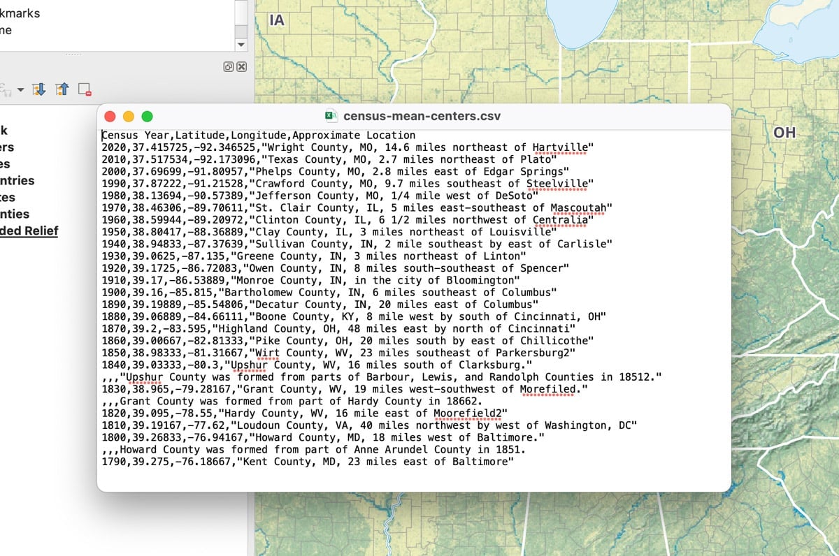
Population Center of the United States
Every ten years, the U.S. Census Bureau maps out the mean and median population centers in the United States.

FABDEM: 30 Meter Resolution Bare Earth DEM from Fathom
FABDEM is the first global Digital Elevation Model (DEM) with forests and buildings removed at a 30m resolution.

Synanthropes at a Horse Stable in Northern California
Synanthropes are wildlife that benefit from living near humans.

Continental vs. Contiguous United States: Key Differences Explained
Continental and contiguous are two geographical words used to describe parts of the United States.

Canada Geese Migrate Less from Urban Areas
With the expansion of urbanization, more Canada geese are becoming year round residents instead of migratory.

Medieval Peutinger Map | Book Review
The Peutinger Map (Tabula Peutingeriana) is a unique medieval replica of a Roman route map from the late fourth to early fifth centuries.

How Many Tree Species are There in the World?
A team of scientists from the UK's Botanic Gardens Conservation International has compiled the first comprehensive list of all the world's tree species.

GIS Reference Books and Materials
Here are some books and GIS reference resources that are valuable for both the novice and seasoned GIS user.

How to Use ArcGIS Pro for Supervised Classification
This ArcGIS Pro tutorial provides a step-by-step guide for performing supervised classification on Landsat 8 imagery using remote sensing and GIS techniques.

Geography of Wild Horses in the United States
Wild horses continue to roam the Western United States as well as parts of the East Coast.

How Ships Create Clouds Over the Oceans
Ships can create a trail of clouds as they travel over the world's oceans.

Can GIS Help Ease Supply Chain Problems and Inflation?
GIS and spatial technologies could help to lessen the impact of supply chains, which are causing some of the high inflation prices.
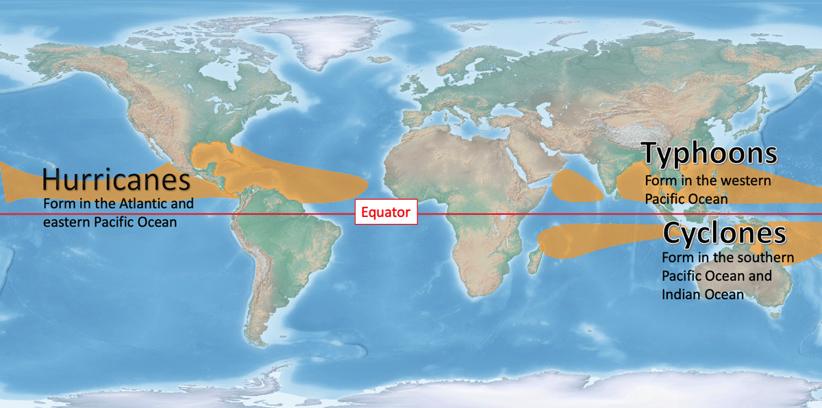
Tropical Cyclones: Hurricanes, Typhoons, and Cyclones
Depending on where the storm system develops, it will be called a hurricane, typhoon, or cyclone.

Geography Facts: Rhode Island
Learn geography trivia about the smallest state in the United States.

The State of GIS Jobs in 2022
Andres Abeyta, Director of Bootcamp GIS reports about the state of GIS jobs as he looks at what skills and experiences job seekers need.

Aerial Snow Mapping
Researchers are increasingly use UAS/UAV platforms for measuring snow cover data, particularly snow depth.