
Articles

Endemic, Native, Non-native, and Invasive Species
Learn what the terms endemic, native, non-native, or invasive mean for animals and plants.

Study: Afforestation Can Lead to More Cloud Cover
Increased forest cover can lead to more low lying clouds which helps to cool the Earth.

First Maps
These maps are the earliest known representations of a particular geography, name, or geographical phenomenon.

The Role of UX and UI in GIS
Jeff Siarto of Element 84 talks with the MapScaping Podcast about the evolving role of design in the geospatial industry.

Which U.S. States are Landlocked?
There are 27 states in the United States that are single, double, or triple landlocked.

Landsat 9 Data Released
Landsat 9 satellite imagery and data has been made publicly available.
Providing a Voice Interface for Geospatial Data
Qwhery CEO Matt Pietryszyn discusses his smart speaker application Q11, that uses voice assistant technology to answer geospatial data queries.

Curling Stones Come from Two Quarries in the World
Almost all of the granite harvested to create curling stones comes from a small isle off the coast of mainland Scotland.

Detecting Methane With Satellites
Satellite technology plays an important role in pinpointing sources of methane emissions, a vital step in mitigating this greenhouse gas.

A Look at 3 Trends Shaping Remote Sensing in the Next 5 Years
Ian Berdie of NV5 Geospatial, discusses three trends that will reshape use of remote sensing over the next five years.

Hearts on Earth
Geographers have a spatial way to celebrate Valentine's Day with these natural heart-shaped land features.

How a Changing Climate is Affecting Forests in the Western United States
Drought, more intense fires, and invasive species are changing the forest landscapes in Western United States.

AI-assisted Mapping of Crop Fields Using Free Sentinel Imagery
Mapflow offers an AI-driven process to map crop fields in QGIS.

Distance Decay in Geography
Distance decay between two groups of people gives rise to things like languages and regional customs, and distance decay across biomes contributes to the earth's natural diversity.

Test Your Knowledge of World Geography with these Online Games
Geoguesser is an online game that uses images from Google Street View to display a small section of the world.

Largest Plateau in the World
The Qinghai–Tibet Plateau is the world's largest plateau.

Arctic Circle
The Arctic Circle is a circle of latitude encompassing the northernmost pole of the Earth and is located at approximately 66°33′45.6″ north of the Equator.

Remote Sensing of Lightning
Satellites and remote sensing tools are providing a way to better forecast and determine the severity of lightning.
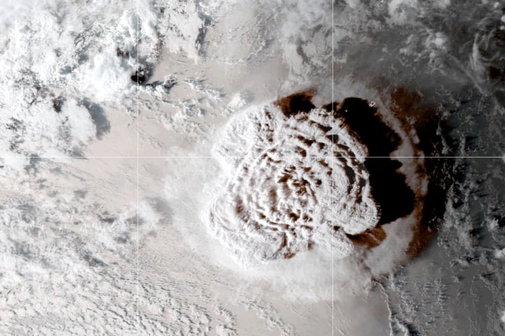
How Big Was the Tonga Volcanic Eruption?
Tonga was rocked by an undersea volcano eruption on January 15, 2022, which sent shockwaves throughout the planet.

Cloud Streets
Cloud streets are cumulus clouds that form in long bands along cylinders of rotating air and are roughly parallel to the ground.

How to Use ArcGIS Pro for Fire Risk Mapping
Tutorial showing how to map fire risk for a region with slope, elevation, aspect, and land use data in ArcGIS Pro.

The First Newly Formed Island to Survive in the Satellite Era
The first newly formed island to survive in the age of remote sensing is Hunga Tonga-Hunga Ha'apai.

Understanding How Carbon Storage Can Help Meet Climate Goals
The storage of carbon is a critical part of rebalancing the carbon cycle to ensure that climate change is less severe than many predict.
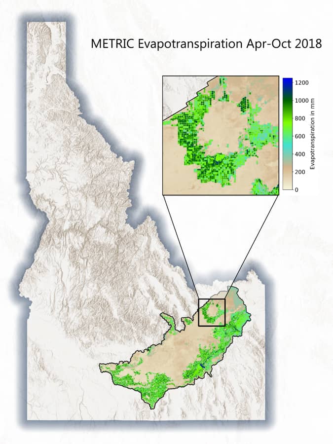
Geospatial Tools for Agricultural Water Management
The use of geospatial technologies can help mitigate inefficient use of water and help improve how this precious resource is used in crop production.

How to Measure Hotel Market Share using the Huff Model in Maptitude
Learn how to map hotel market share to measure a city's tourism attractiveness using Maptitude.

Greatest Concentration of Breeding Bald Eagles in the Continental U.S.
The San Juan Islands in Washington has the highest concentration of breeding bald eagles in the continental United States.