
Articles

Why GRASS Delivers Powerful GIS Capabilities
A recent MapScaping podcast with Markus Neteler, chairman on the GRASS GIS Project Steering Committee, makes it is clear that GRASS will continue to be a powerful GIS open source effort for years to come.

Geospatial Technology and Challenges of Contemporary Agriculture
Farmers have greater access to geospatial tools that can help mitigate some agricultural challenges.

WebGIS Section 1 – A Quick Introduction to GIS and WebGIS
In section 1 of this series on WebGIS, Emmanuel Jolaiya provides readers with an overview of GIS and WebGIS.
Series: WebGIS Using Open Source Tools
Emmanuel Jolaiya's series on WebGIS using open source geospatial tools and technologies.
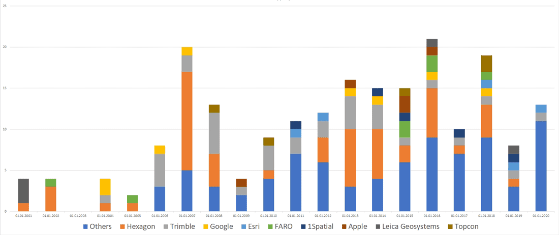
Mergers and Acquisitions in the Geospatial Market (2001-2020)
Andrey Pirogov, founder of GISGeo Project, takes a look at mergers and acquisitions in the geospatial technology market from 2001 to September 2020.

Review | The Best American Travel Writing 2020
Travel writing as it should be – we are invited to learn from the setting of lessons by the learned and the observant.

The World’s Biggest Seagrass Restoration Project Is Good News for Marine Life and Climate
Researchers have been conducting the world’s most extensive seagrass meadow restoration.

Mapping Sea-Level Rise with Sentinel-6
The recent launch of Sentinel-6 Michael Freilich/Jason CS is the latest mission that will collect high resolution sea level measurements.
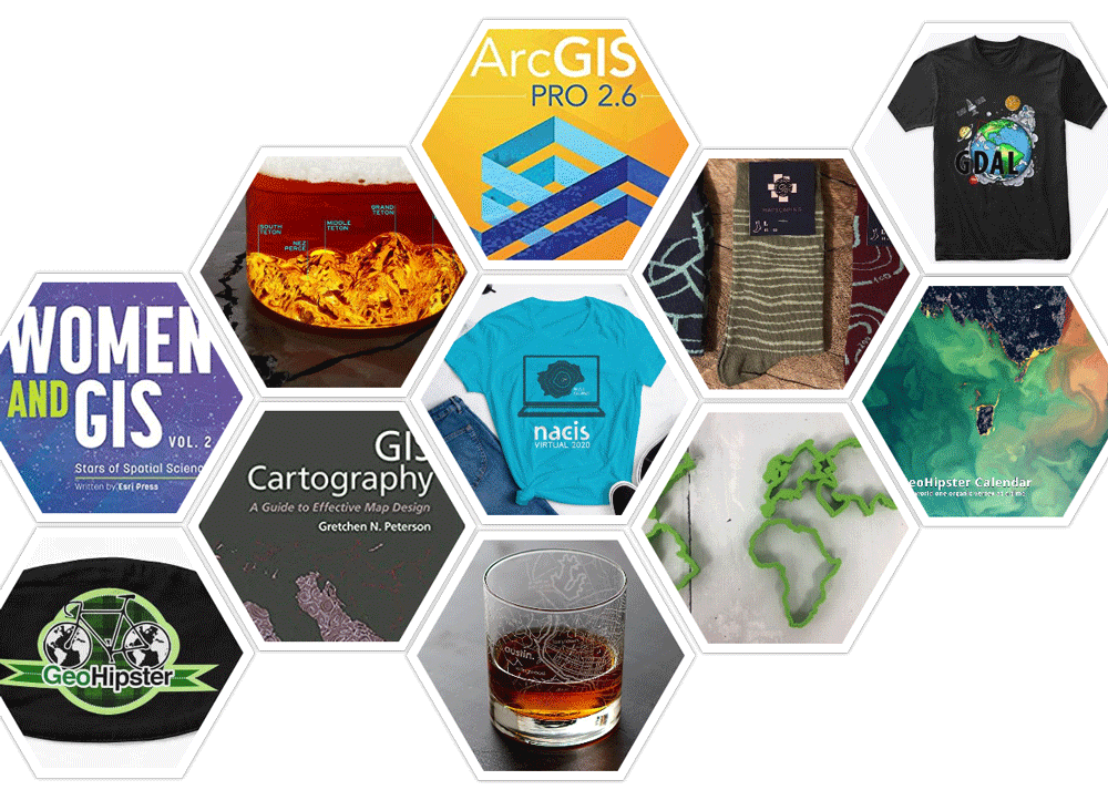
2020 Gift Guide For the GIS Person in Your Life
Looking for a gift for your favorite GIS person? Here's a list of geo-related suggestions for a range of budgets.

Geography of Thanksgiving
Each November, families in the United States gather to celebrate Thanksgiving.

Understanding Central Place Theory: Key Concepts in Urban Geography
In 1933, Walter Christaller introduced Central Place Theory (CPT) as a way to explain the location, number, and size of settlements.

New “Map Projections for Babies” Board Book Helps Encourage Early Communication and Learning
Dan Ford explains how support from the geospatial community will help bring the "Map Projections for Babies" board book to life.

How to Create Public Transport Isochrones in ArcGIS Pro
This tutorial shows GIS users how they can create public transport isochrones using ArcGIS and the TravelTime plugin.

QGIS Style Sharing Repository
A new tool has been deployed that lets QGIS users share style files.

What are 15-Minute Cities?
What if you could get from home to your job to the grocery store to the park, all in 15 minutes?

Mapping Carbon Dioxide Emissions from Soil Respiration
Researchers recently developed a map of the global distribution of mean annual soil respiration (Rs) between 2000 and 2014.
Sub-branches of Human Geography
Human geography focuses on the role that human play in the world.

Sub-branches of Physical Geography
Physical geography is one of the two primary branches of geography.

Study Finds Staggering Decline in Marine Fishery Biomass
A recent global long-term fishery biomass trends evaluation has found an alarming decline in fish populations worldwide.

Converting Historical Maps to Satellite-Like Imagery
Old maps and images can now be converted to make them similar to our modern satellite-base views, giving stylized views a more realistic appearance.

The Potential Role of GIS in COVID-19 Vaccine Distribution
GIS can play a role in developing protocols for the distribution of COVID-19 vaccines.

The Only Metric Highway in the United States
Currently, only three countries in the world have not adopted the metric system as the standard: The United States, Myanmar, and Liberia.

What is the AP Human Geography Exam?
The AP Human Geography exam requires in depth knowledge and analytical skills in a range of topics in the sub-branch of geography.

Halloween GIS Fun
Looking to add a little geo to your Halloween beyond the proliferation of Halloween Trick or Treater online maps? Halloween ...

Three of Colorado’s Wildfires are the Largest in Recorded History for the State
Widespread drought and heat waves are helping to fuel a record-breaking fire season in Colorado.

Rapid Growth Shortens Trees’ Lifespans – and Adds to the Climate Crisis
Researchers have found that trees growing faster due to warming conditions are also dying faster.