
GIS and Geospatial Technologies
Articles focusing on the application of geographic information systems (GIS), geospatial technologies, remote sensing, LiDAR, and Global Positioning System (GPS). These technologies serve as critical tools for understanding and interacting with our physical environment. GIS allows for the mapping and analysis of spatial data Geospatial technologies refer to the various tools used to measure and analyze Earth’s lands and resources. Remote sensing provides a way to collect data from a distance, often via satellites or high-flying aircraft, and is commonly used for environmental monitoring and military applications.
GIS subcategories :
GIS Career | GIS Data | GIS Industry | GIS Learning | GIS Software | GPS | Remote Sensing | Spatial Analysis

Mapping Oil Slicks With Satellite Imagery
Sentinel-1 synthetic aperture radar (SAR) satellite data has been used in a study to map oil slicks.
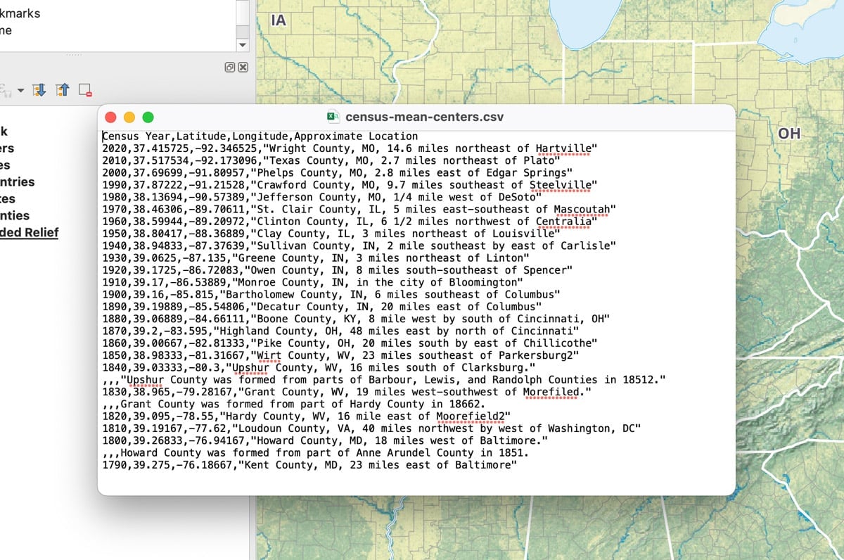
How to Add Latitude and Longitude as a CSV File in QGIS
This quick QGIS tutorial takes you through the steps of how to add a CSV file with latitude and longitude coordinates.

FABDEM: 30 Meter Resolution Bare Earth DEM from Fathom
FABDEM is the first global Digital Elevation Model (DEM) with forests and buildings removed at a 30m resolution.

GIS Reference Books and Materials
Here are some books and GIS reference resources that are valuable for both the novice and seasoned GIS user.

How to Use ArcGIS Pro for Supervised Classification
This ArcGIS Pro tutorial provides a step-by-step guide for performing supervised classification on Landsat 8 imagery using remote sensing and GIS techniques.

Can GIS Help Ease Supply Chain Problems and Inflation?
GIS and spatial technologies could help to lessen the impact of supply chains, which are causing some of the high inflation prices.

The State of GIS Jobs in 2022
Andres Abeyta, Director of Bootcamp GIS reports about the state of GIS jobs as he looks at what skills and experiences job seekers need.

Aerial Snow Mapping
Researchers are increasingly use UAS/UAV platforms for measuring snow cover data, particularly snow depth.

Reliability of Machine Learning Maps
Academics are increasingly adopting machine learning maps to better understand what can happen for a range of environmental events.

Fluid Earth: Open-source Visualization of Weather and Climate Data
Fluid Earth is a web visualization tool developed by The Ohio State University's Byrd Polar and Climate Research Center (BPCRC) that enables users to view weather and climate patterns.

Measuring Nitrogen Dioxide Levels in Urban Zones using Geospatial Methods
Earth observation and geospatial techniques have improved the ability to measure nitrogen dioxide at ground level.

Big Data and Animal Migration
Scientists are using big data methods combined with modern GPS tracking and machine learning to enhance their understanding of global animal migration patterns.

Higher Resolution U.S. Flood Maps
Researchers have developed a high resolution flood map for the United States.
GIS Job Definitions
What are the different types of geospatial job listings out there? Listed here is the list of different GIS, which ...

Mapping the Sounds of the Ocean
Using hydrophones, scientists convert sound waves to electrical signals to create images of underwater ocean environments.

Lidar Explained
Lidar is a technology developed to map the elevation of features on and below the surface of the Earth.

Extracting Geospatial Data from Historical Maps
Geospatial methods can detect location names from historical maps, make them searchable, and allow for the automated extraction of geographic data from those maps.
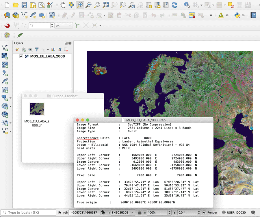
What is a GeoTIFF?
A GeoTIFF is a public domain metadata standard which has the georeferencing information embedded within the image file.

How to Use ArcGIS Pro to Estimate Soil Erosion from a Catchment Basin
This lesson shows how to use spatial data science and remote sensing techniques in ArcGIS Pro to predict soil erosion in a catchment area using the Universal Soil Loss Equation (USLE).
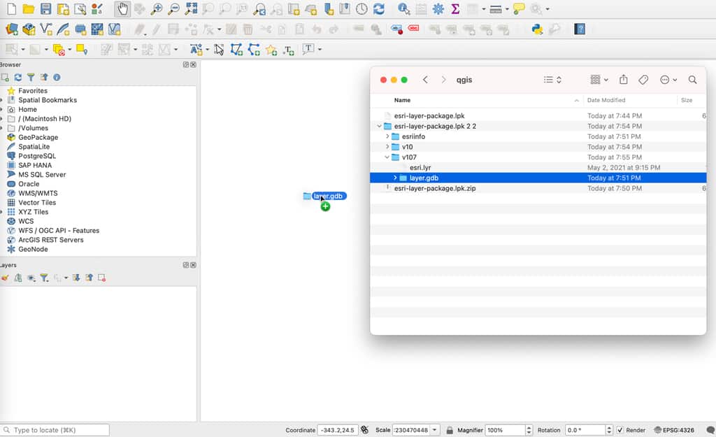
How to Import an Esri Layer Package in QGIS
While QGIS cannot directly read an Esri layer package, there is a simple technique to unpack the file and import it into this GIS software.

Kriging in Geography
Spatial kriging is a commonly used interpolation technique for estimating raster values.

The Role of UX and UI in GIS
Jeff Siarto of Element 84 talks with the MapScaping Podcast about the evolving role of design in the geospatial industry.
Providing a Voice Interface for Geospatial Data
Qwhery CEO Matt Pietryszyn discusses his smart speaker application Q11, that uses voice assistant technology to answer geospatial data queries.

Remote Sensing of Lightning
Satellites and remote sensing tools are providing a way to better forecast and determine the severity of lightning.

How to Use ArcGIS Pro for Fire Risk Mapping
Tutorial showing how to map fire risk for a region with slope, elevation, aspect, and land use data in ArcGIS Pro.
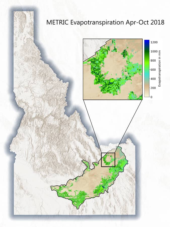
Geospatial Tools for Agricultural Water Management
The use of geospatial technologies can help mitigate inefficient use of water and help improve how this precious resource is used in crop production.