
GIS and Geospatial Technologies
Articles focusing on the application of geographic information systems (GIS), geospatial technologies, remote sensing, LiDAR, and Global Positioning System (GPS). These technologies serve as critical tools for understanding and interacting with our physical environment. GIS allows for the mapping and analysis of spatial data Geospatial technologies refer to the various tools used to measure and analyze Earth’s lands and resources. Remote sensing provides a way to collect data from a distance, often via satellites or high-flying aircraft, and is commonly used for environmental monitoring and military applications.
GIS subcategories :
GIS Career | GIS Data | GIS Industry | GIS Learning | GIS Software | GPS | Remote Sensing | Spatial Analysis
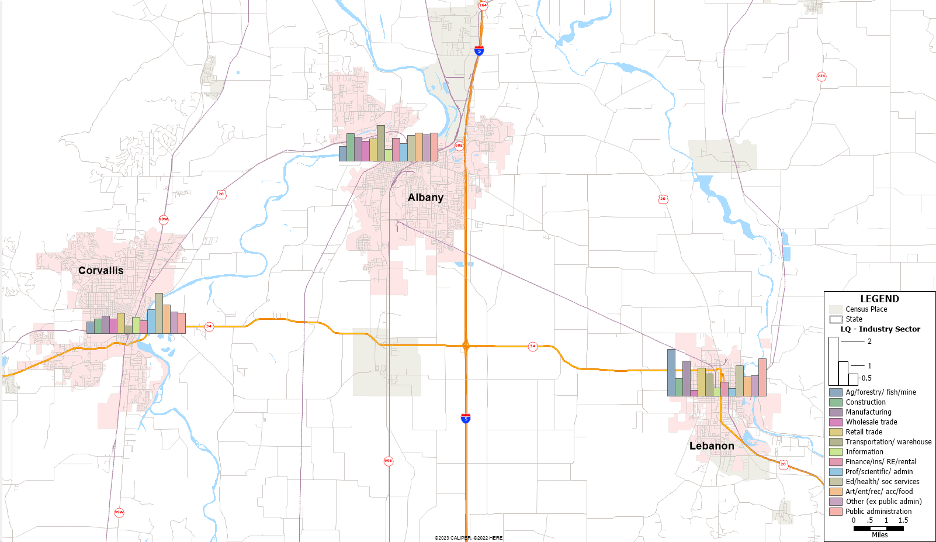
Using GIS to Map Trends in Employment
This tutorials shows users how to analyze ACS data from the US Census Bureau to calculate employment shift-share and location quotient using Maptitude.

Mapping Heat in U.S. Cities
NOAA has been coordinating an effort to map urban heat islands in cities across the United States.
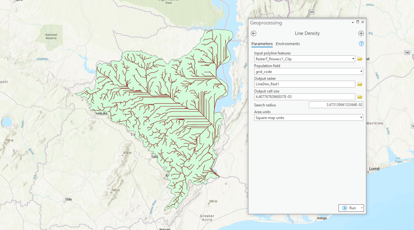
How to Map Watersheds Using ArcGIS Pro: A Step-by-Step Guide
This tutorial shows you how to use ArcGIS Pro to delineate watersheds and drainage paths from elevation data.

Five Reasons to Start Using QGIS
Here are five compelling reasons to start using the open-source GIS platform QGIS, a free and open source software.
GIS and Cartography Quotes
Looking for a memorable GIS quote? Check out this growing collection of interesting and notable quotes relating to GIS, cartography, maps, and geography.

A Guide to Understanding Map Scale in Cartography
Map scale refers to the ratio between the distance on a map and the corresponding distance on the Earth's surface.

Overview of Elevation Data
This article reviews some of terminology and types of elevation based datasets available to GIS.

Highly Detailed Seafloor Maps
Researchers from MBARI have developed methods to map the ocean floor at incredibly high resolution.

How to Use the Suitability Modeler in ArcGIS Pro
Learn how to use the suitability modeler in ArcGIS Pro to map out suitable areas given a set of criteria.

GIS and Map Contests
Current map and GIS related competitions listed in order of the competition deadline.

How Remote Sensing and GIS Are Improving Wildfire Forecasting
Advances in GIS, satellite imagery, and AI are helping scientists forecast where wildfires are most likely to ignite, spread, and produce hazardous smoke.

R Packages for Spatial Analysis
Looking for R spatial packages? Listed here is a brief look some of the spatial packages in R that are available.
Where Should You Ask Your GIS Questions?
Here are some excellent resources for you to get peer assistance for your GIS related questions.
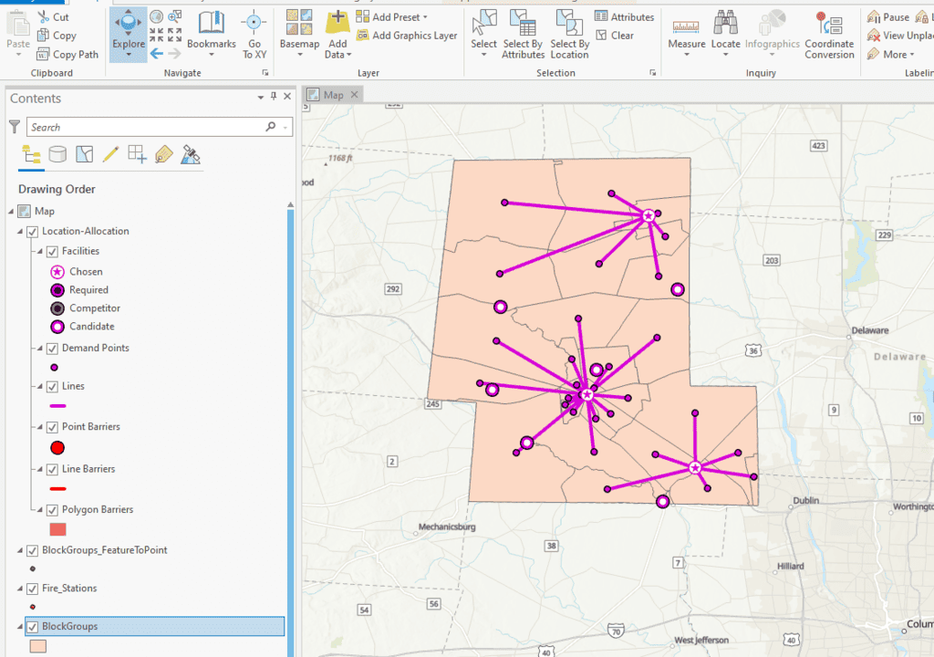
How to Perform Location Allocation Analysis in ArcGIS Pro
This ArcGIS Pro tutorial uses hospital and fire station GIS data to analyze services areas and location allocation.

Certification in GIS
GIS certification is a professional credential that validates an individual's proficiency in using and understanding geographic information systems.
Basic Uses of GIS
What are the basic uses of GIS? This article reviews some of the most common and basic users of GIS including mapping data, proximity analysis, buffers, cluster mapping, and querying a geographic area for features.

Mapping Tornado Tracks with Satellite Data
Researchers used satellite imagery and remote sensing to map tornado tracks.
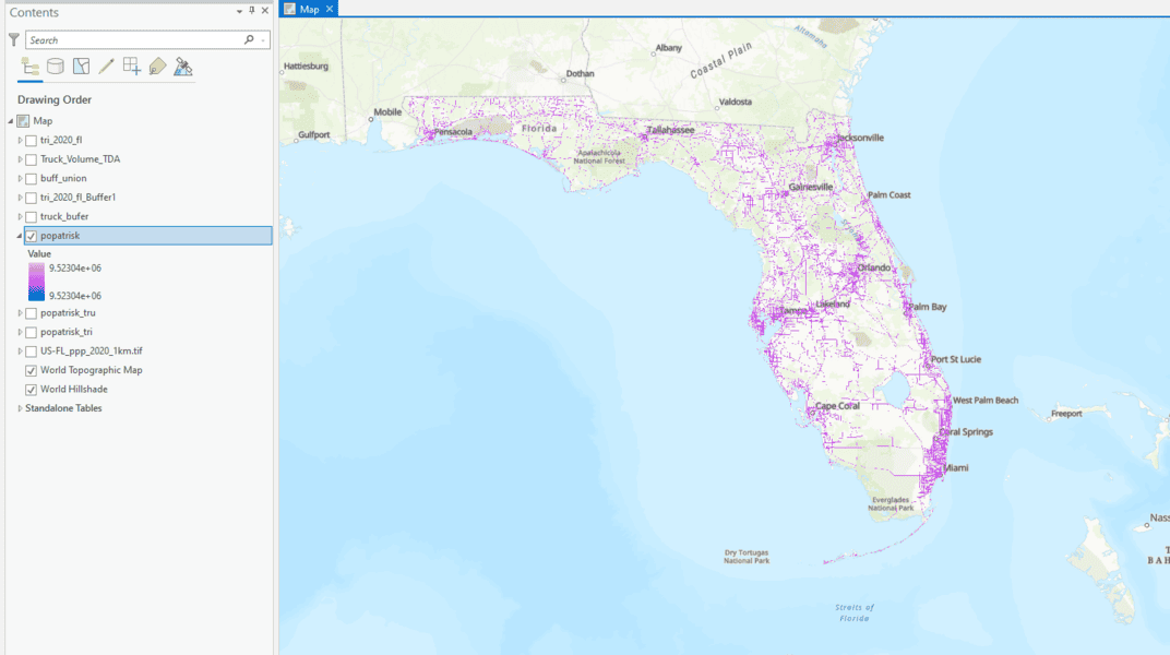
How to Use ArcGIS Pro to Determine the Population Impacted by Air Pollution
Learn to estimate air pollution's impact on people with geospatial methods using ArcGIS Pro and data from Toxic Release Inventory, Worldpop, and ArcGIS Hub.
Free Ways to Learn QGIS
If you want to start learning how to use QGIS, a free and open source GIS software package, there are some excellent free resources out there.

Networking in GIS: Peer-to-Peer Support in the GIS Community
List of peer-to-peer resources that GIS professionals can tap into for assistance with their technical queries and to connect with others in the field.
Learn GIS for Free
There are a few online options to learn GIS for free. Take advantage of resources that provide you access to free courses from some of the world's best universities and institutions.

How to Learn GIS
There are many ways to learn GIS. Listed here are guides to learn GIS in a classroom, online, or through self-guided methods.

Finding the Right GIS Program
Choosing the right GIS educational program to set you on the right path towards a GIS career, so be sure to consider all your options before making a decision.
How to Find Internships in GIS
Tips for finding a GIS internship: check job boards and internship websites, reach out to local employers, attend career fairs and events, and network.

A Guide to Understanding Map Projections
Map projections are techniques used to transform the Earth's three-dimensional surface onto a two-dimensional plane, inevitably introducing some distortion in area, shape, distance, direction, or scale.
Real-time Satellite Tracking
N2YO.com is an online service that offers satellite tracking and information in real-time.